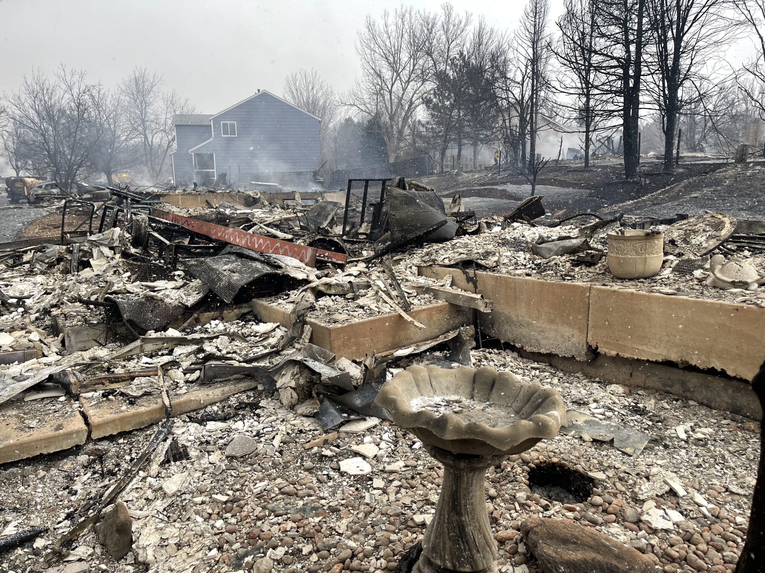
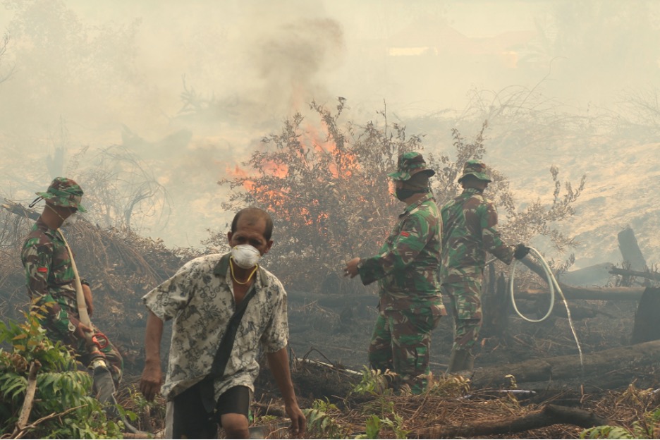
On December 30th, 2021, the Marshall Fire broke out in suburban communities south-east of the idyllic city of Boulder, Colorado, located at the foot of the Rocky Mountains in the United States. Within hours, the fire burned roughly 1,000 homes down to their foundations. It was deemed an “urban fire storm” by climate scientist and Boulder local Daniel Swain.
In our everyday lives we encounter and are exposed to a dizzying array of chemicals – through the air we breathe, water we drink, food we eat, products we buy, work we do, and environments we move through. A recent review of the scientific literature estimates that the accelerating mass-production of chemicals has led to the accumulation of 350,000 “novel entities” (human-made chemicals that did not previously exist) in the environment.[1] They suggest this exceeds the “planetary boundary” for chemical pollution, meaning it is and will continue to disrupt the operation of ecological systems and have major impacts on human health.
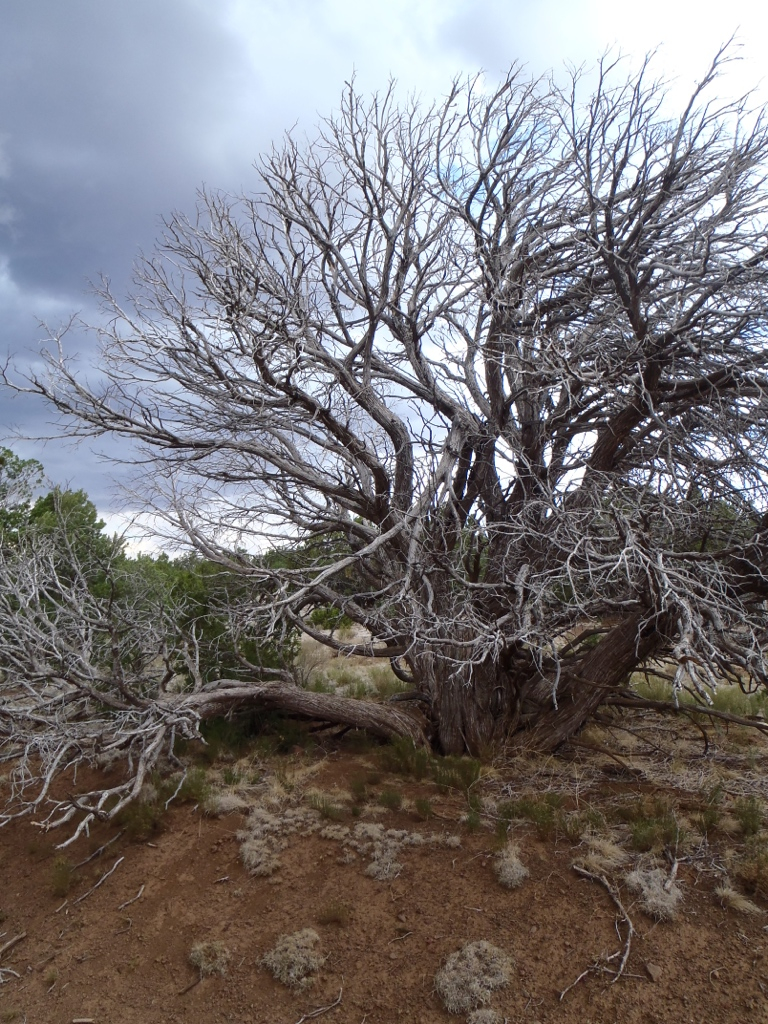
“My forest is dying,” he said as we drove northwest on highway 180 through the Coconino National Forest. I looked out the truck window at the many brown and gray lifeless trees among the green and I asked if that wasn’t normal for summer. Billy, a seasonal wildland firefighter, said no, there were many more brown trees this year in July than previous years. It was a visual sign of what environmental scientists call forest morality. A warning that the Coconino National Forest could be reaching a tipping point.
Figure 1. A dead tree in the Coconino National Forest. Photo by author.
“Fireways” evokes the complex interactions between fire and humans. Each year the Coconino National Forest burns; each year it grows back. Yet an impact of anthropogenic climate change is drought, drying out the trees and leaving them less likely to return after fires that burn hotter and more frequently. Fire management policies have also affected the life of the forest, with an emphasis on suppression leaving the forest at risk from more intense blazes. This is the “fire paradox” of contemporary fire ecology, in which ever increasingly bigger blazes are caused by a combination of suppression policy and climate change, with each problem compounding the other.
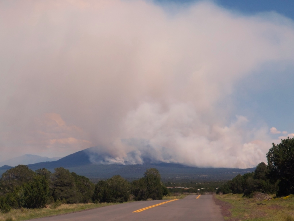
Figure 2. A forest fire burns on a mountain near Williams, Arizona. Photo by author.
More intense, frequent, and complex fires burn each year over longer fire seasons, with so-called “megafires” occurring over the past thirty years. The Indigenous people of the area, such as the Apache, practiced controlled burning to manage the forest. This practice has been taken up by the “good fire” movement, which advocates regular lighting of controlled burns to reduce fuel. Less fuel in the form of brush and dead trees means that intense fires and megafires are less likely.
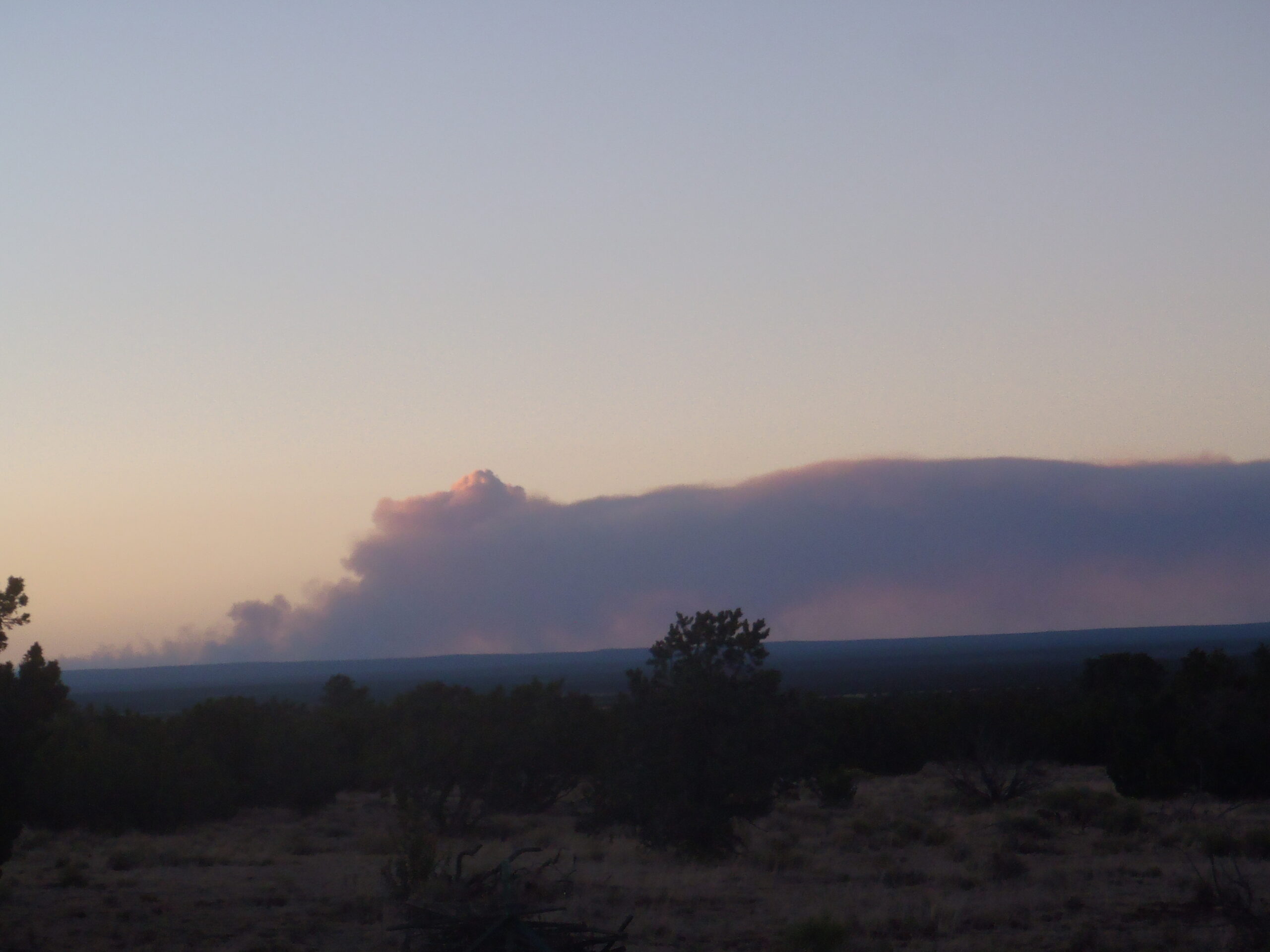
Figure 3. A forest fire on the Colorado Plateau. Photo by author.
In Arizona, fire seasons are a regular part of the climatological cycle in a fire-adapted ecosystem. The Coconino National Forest covers a large part of Northern Arizona. It is the largest contiguous ponderosa pine forest in the world. Each year during the fire season from May-July, large forest fires burn. The predominant cause of forest fires is lightning. Fire season ends when the monsoon rains come, usually in August-September.
Figure 4. Monsoon rain clouds over Flagstaff, Arizona. Photo by author.
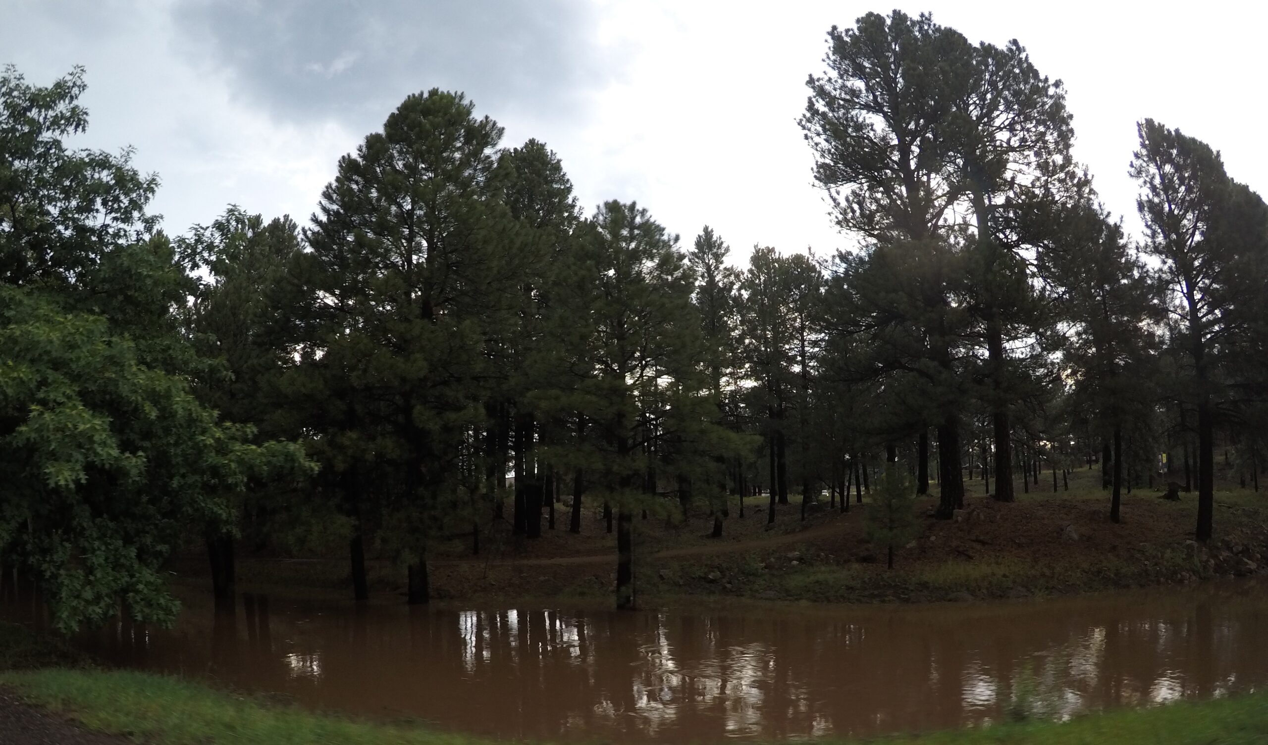
Forest fires in Arizona have gotten worse. In recent years, monsoons have been weaker, and the fire season is prolonged by a few days. Some years, the rainfall is so insignificant that local people call it a “nonsoon” year. Other years, intense bursts of sudden rainfall causes flash floods. The fires strip the land of trees and vegetation, which along with soil erosion, leaves the surrounding communities vulnerable to mudslides. In June 2021, monsoon rains caused flooding and mudslides through the site of the burn scar from the Museum Fire of 2019. Video captured flood waters sweeping away a Toyota Prius as mud and brown water coursed through neighborhoods close to downtown.
Figure 5. Flooding in the Rio de Flag wash in Flagstaff, Arizona. Photo by author.
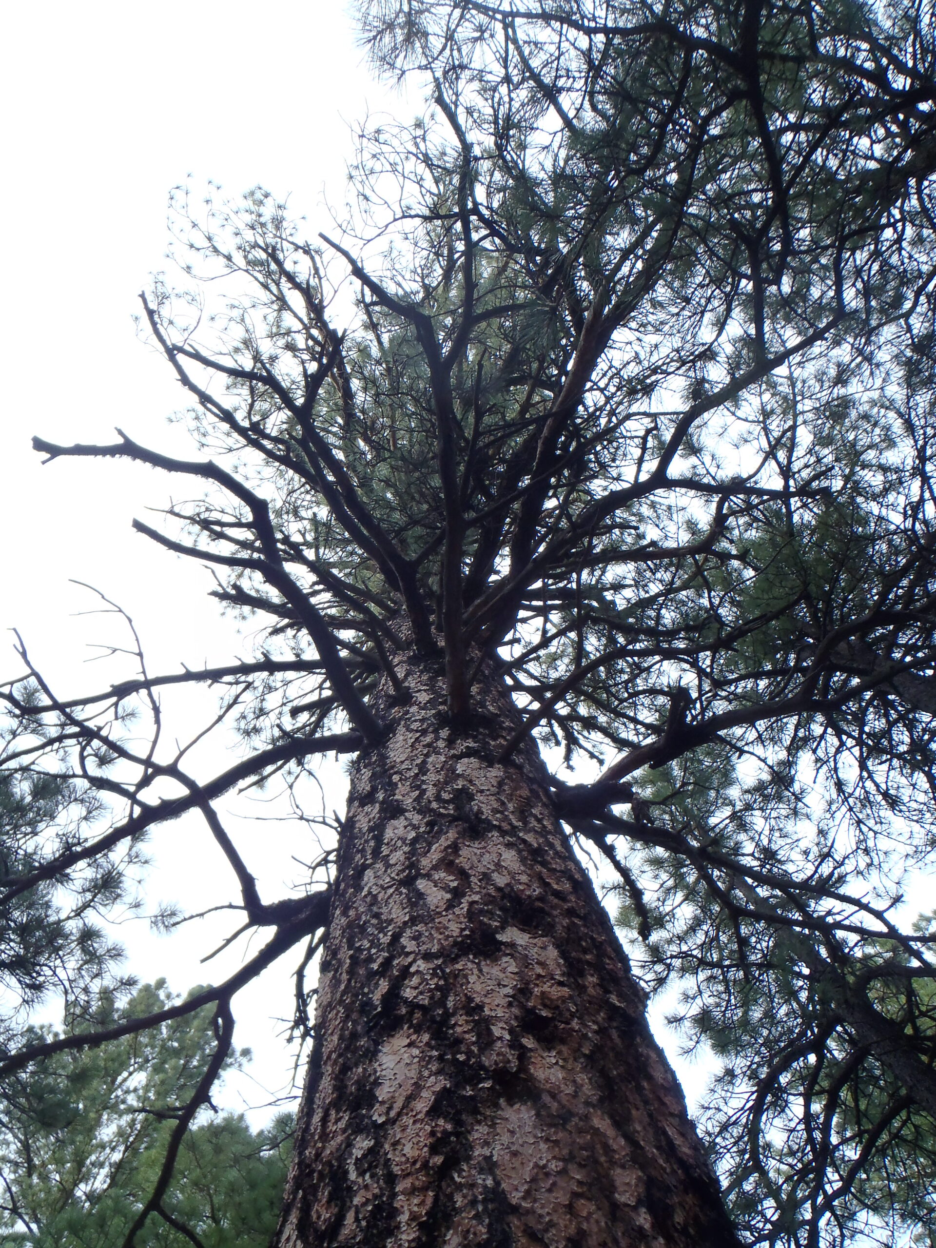
Ponderosa pine trees make up much of the tree growth in the Coconino National Forest. Ponderosas do not grow at higher temperatures. As the average temperature rises due to anthropogenic climate change, the ponderosas recede. Fire is necessary for tree reproduction in the forest, clearing the grasses and scrub so the larger trees can grow in the regenerated soils. Ponderosas have a thick, fire-resistant bark. The low-intensity fires of 100-years ago burned the grasses but did not reach the lower branches of the tall ponderosas.
Figure 6. A ponderosa pine tree. Photo by author.
Now more intense fires are burning entire tree stands. Ponderosas only reproduce via seeds, which only scatter a certain distance from a parent tree. If a whole stand burns, it is much harder for the seeds to regrow. Literature from tree surveys show that the forest is close to its tipping point, after which the annual fires will destroy so many trees they will be unable to grow back.
The US Forest Service is responsible for fire management in the Coconino National Forest. In recent years, they have begun to light more controlled burns to reduce the fuel in the forest and decrease the intensity of forest fires. The aim is to reinstate a fire regime that encourages the dispersal of seeds and renewal of soils that promote forest health. However, local people complain about controlled burns, perceiving them as dangerous, reducing air quality due to smoke, and increasing closures of the forest for recreational use.
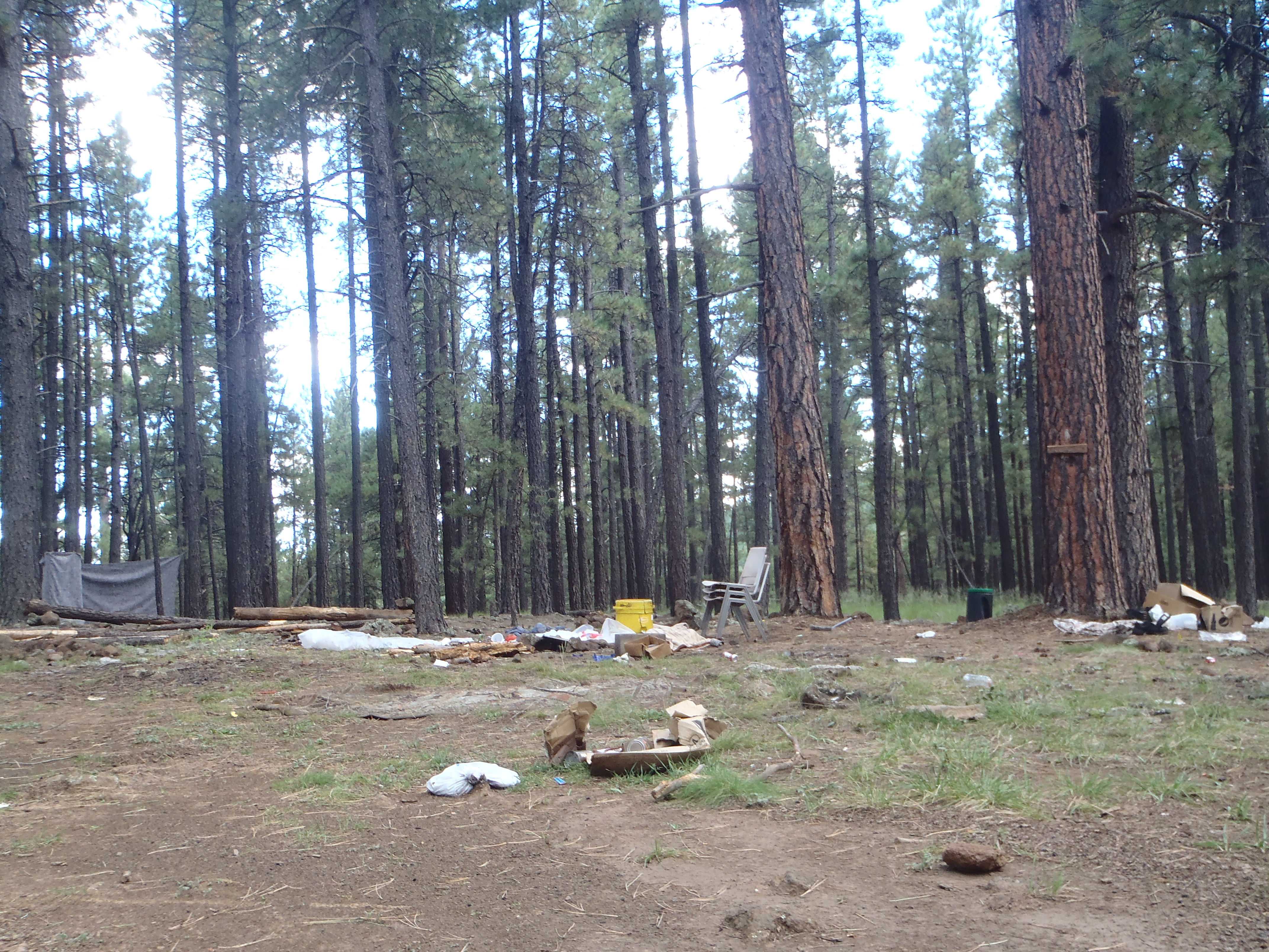
Local people and visitors use the forest extensively for hiking, camping, and outdoor sports. Recently, the Forest Service has tried to limit use of the forest around the Verde Valley area by restricting camping to approved campsites only. There are perennial problems with trash left in the forest by campers and stray sparks from campfires and cigarettes igniting forest fires. However, the Forest Service also encourages recreational use of the forest, such as by leasing land to a ski resort on the San Francisco Peaks. This is one of the sacred mountains to the Diné people (Navajo), many of whom object to the presence of a ski resort. Historically, the Forest Service has also been responsible for opening large tracts of the forest to logging.
Figure 7. Remains of a campsite in the Coconino National Forest near Flagstaff. Photo by author.
As fires burn tree stands that are unable to regrow, the forest is turned to grassland. In the process, what was a carbon sink becomes a carbon source. The fire paradox of anthropogenic climate change and management policies of suppression are creating wildfires of such magnitude that will ultimately bring abrupt ecological change to the forest.
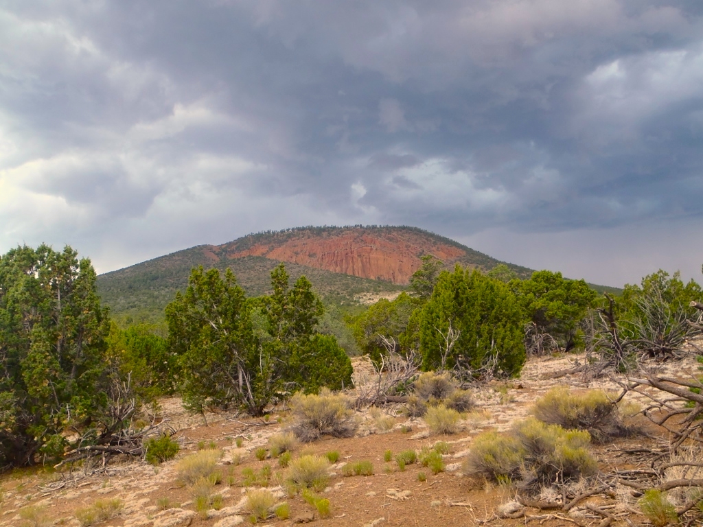
Figure 8. Dead and living trees surround Red Mountain in the Coconino National Forest, Arizona. Photo by author.
Susannah Crockford is a lecturer in anthropology at the University of Exeter, UK. Her research interests cover the ethnographic study of ecology, religion, and medicine, with field sites in the southern and midwestern US and northern Europe. She has been visiting Northern Arizona for fieldwork since 2012. Her first monograph was published in May 2021 by the Class 200 list of the University of Chicago Press, titled Ripples of the Universe: Spirituality in Sedona, Arizona. Her next book will be an ethnography of climate change. Follow on Twitter: @suscrockford.
In Fabian Scheidler’s The End of the Megamachine, he draws on the work of environmental historian Lewis Mumford to show how certain forms of social organization seem machine-like, even if, in the end, they are made up by people. To recognize that the totalizing systems we are forced to engage with daily are not inexorable machines, but the results of an infinite number of decisions by an enormous number of people, can both be depressing or hope giving, depend on how this fact is viewed.
Scheidler’s diagnosis of the megamachine is important, because he focuses on the military need for mining, which lead to industrialization, which has also driven the chemical industry. The corporate-state complex has been predicated on increased control and manipulation of people and the natural environment – colonialism has occurred at countless levels before it has been able to move on to the next. “Before colonizing the world, Europe itself had been brutally colonized,” Scheidler writes.[1] The missionary purpose of religion, doing God’s work by culling infidels and baptizing more and more converts into the flock, served as the template for colonization, which now takes the secularized face of accumulation to support ever increasing disparities in quality of life and lifestyle.
The irony of instrumentalism, even for the highest conceivable good becomes apparent when we look historically at the collateral damage written out of hegemonic discourse. As Scheidler describes it, “[t]he narrative of a mission to save humanity justifies and allows the destruction of other forms of social organization.”[2] These are the casualties of the war on nature: people, places, relationships; all for the sake of a larger secularized religious project of progress. The pretext for the ‘side-effect’ of pollution has been ‘better living through science’ – the always-delayed promise of trickle-down prosperity making the serial sacrifice of the marginalized worth it. Political theorist Danielle Allen describes the democracy-eroding consequences of requiring certain portions of the population to sacrifice for the collective without equitably distributing the costs and benefits.[3] Too often, the expectation of personal sacrifice for the collective gets codified into systematic expectations, creating hierarchies of dominance congealing into discrimination.
Of course, the promised exchange of abundance for ecological destruction is nothing new, but in fact has been a central tenet of extractivism since the mining operations of medieval Europe. In order to see the global displacement of harms from economic centers to economic peripheries as not new, but based on the megamachine permanent war economy of maximum exploitation, Carolyn Merchant reminds us in her The Death of Nature that complaints and gaslighting around environmental injustice existed in pre-colonial Europe as well:
most mines occurred in unproductive, gloomy areas. Where the trees were removed from more productive sites, fertile fields could be created, the profits from which would reimburse local inhabitants for their losses in timber supplies. Where the birds and animals had been destroyed by mining operations, the profits could be used to purchase “birds without number” and “edible beasts and fish elsewhere” and refurbish the area.
Since the twentieth century, this same logic has been applied to industrialized mining worldwide. Hypothetical future returns justify present damage, including destruction of the ecological basis of local cultures, a phenomenon termed “semiocide” (semiotic ecocide/suicide) for the demolition of meaning that comes from the loss of memory and situatedness associated with habitat destruction.[5]
Phosphorus mining as paradigmatic of extractivism
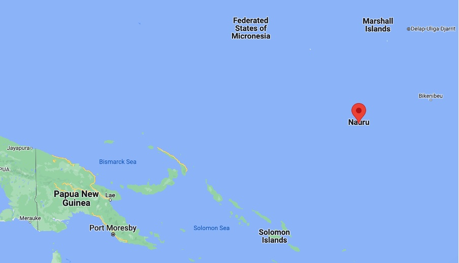
To see how this plays out in recent times, investigating the case of how mining led to ecological destruction, which despite just compensation in a different currency, led to semiocide and the decline of a once vibrant culture, let’s turn to the mining of phosphorus on the island of Nauru.
This fifteenth element on the periodic table accounts for 1% of human body mass, and is crucial for agriculture. In a 1959 essay, Isaac Asimov called phosphorus “life’s bottleneck,” as perhaps more than any other element it determines the carrying capacity for planet earth. Historically, phosphorous-rich human waste was a prized fertilizer, freely available and essential for growing food. Romans used to pay households for collecting their urine to wash the public laundry, as it made an excellent detergent for clothes. But the sanitation revolution killed access to human sources of phosphorous – literally flushing it down the toilet into the sea, where it becomes inaccessible for recapture. This is part of a larger tendency of industrialized humans to take from the earth without giving back, creating what Marx called the “metabolic rift” – the short-circuiting of circular material economies.
Now, we dig up mountains to mine the same precious element we flush down the toilet. With the discovery of mineral deposits of phosphate rock, these nonrenewable resources temporarily lended an unnatural amount of otherwise scarce renewable resources to grow the human population and unsustainable industrialized practices. (The parallels to fossil fuel (especially oil) extraction are manifold.) Between 1950 and 2000, a sixfold increase in global phosphate-rock production has occurred. Yet, even with mining these deposits, demand is rising twice as fast as supply. And this production has come at astronomical costs.
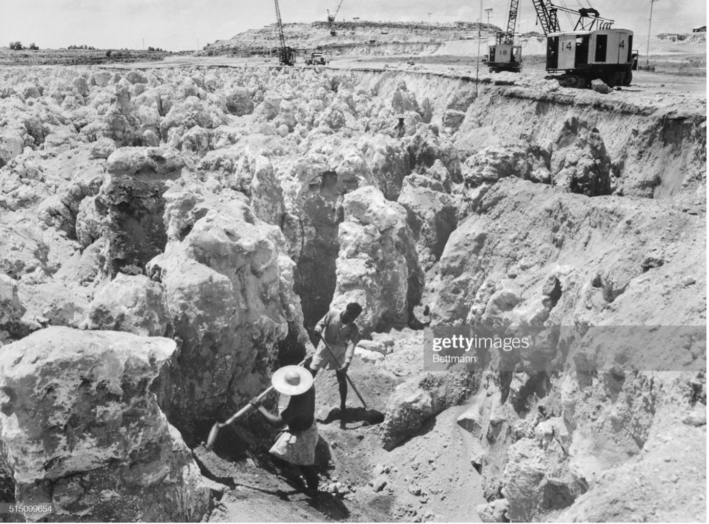
In 1900 phosphate was discovered on the economically poor but culturally and ecologically prosperous central Pacific island of Nauru. The residents were given an offer too good to refuse – partly because they had little choice in the matter of imperial powers hungry for resources – and in a forward-thinking act at the time, a trust was set up for the island’s 10,000 inhabitants, with the accumulated proceeds from mining to provide income in perpetuity. During the height of the almost century of phosphorous exploitation, the people of Nauru had some of the highest incomes worldwide. However, after the resources were exhausted in the 1990s, and the funds in the trust shrank, the social disintegration and ecological devastation which had been momentarily bracketed and tolerated due to the influx of non-renewable quick money, reemerged like whiplash. About 80% of the once-lush island is totally devastated from phosphate strip-mining, and alcoholism, depression, and diabetes plagues the population.[6] In a 2019 exposé, children interviewed would respond to even simple questions with “I want to kill myself.”
Phosphate mining in Nauru, 1968, where four-fifths of the island is now mined. Bettmann Archive.
Even all the money in the world couldn’t put the country of Nauru back together again. This is a basic wound in environmental justice that too easily gets overlooked in settlements and post facto compensatory schemes. The Ponzi scheme of exchanging natural “capital” for financial “capital” and pretending that the denominator is the same, instead of an incommensurable exchange, is partly to blame for Nauru being not an outlier, but the paradigmatic case for extractivism. As historian of the megamachine Robert Proctor calls the structured ignorance that makes such unfortunate ‘mistakes’ so common, ignorance is often actively constructed to instrumentalize some people for the sake of others. In other words, the epistemological foundation such schemes are based on are “made, maintained, and manipulated by means of certain arts and sciences.”[7]
Overcoming Regulatory Whack-a-Mole
Injustice anywhere is a threat to justice everywhere.
Rev. Dr. Martin Luther King, Jr.
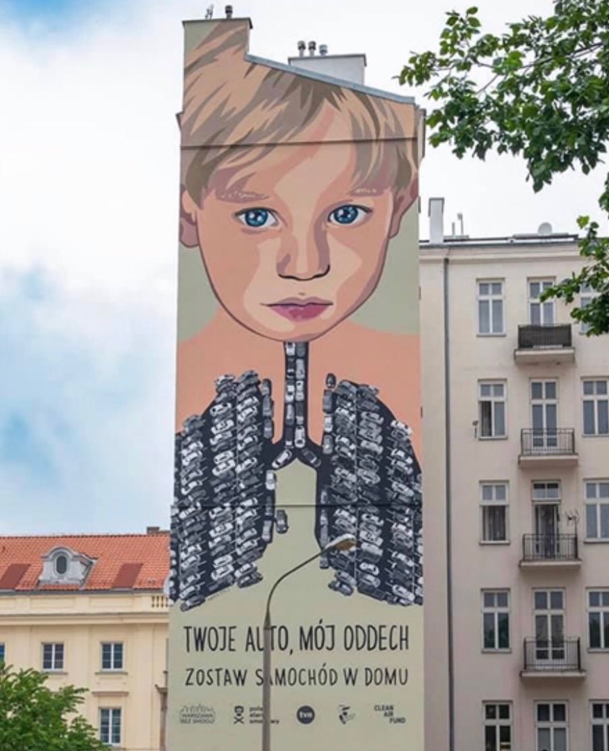
The relationships entrenched in mining are paradigmatic but not exceptional for chemical pollution and the strategy of the chemical and fossil fuel industries. For example, a globalized world of trade makes too easy the ball-and-cup street trick of carbon accounting, allowing a false sense of accomplishment when all rich countries have done is export their emissions, rather than reducing them.[8] Whereas Europe and the US suffered unbearable pollution in the 1960s and 70s, now it is Accra, Hotan, Manikganj, Delhi, which are the manufacturing centers, suffering locally the pollution from the production of products exported to richer areas. The Environmental Kuznet’s Curve (EKC) was wrong: pollution doesn’t go down when people are rich enough to realize their industrial culture is killing them—it just gets exported.
“Your car, my breath,” by Marta Frej
This logic of displacement has been long noticed by many astute observers. From indigenous critiques of industrial culture to systems theorists wary of the back-slapping self-congratulations of Western, Educated, Industrialized, Rich Democratic (WEIRD) countries,[9] sustainability discourse has too often been cover for NIMBYism.[10] If we are to approach a just transition away from ecocide, this requires NIABYism: Instead of “not in my backyard,” when we acknowledge that pollution is linked to preexisting inequality, we realize that what we really need are coordinated policies that render odious industries “not in anybody’s backyard.”[11] And those who wish to fight for the maintenance of environmental injustice-producing contamination have an imperative to move next to those sources of extraction, those disease-causing factories. If they believe in the sanctity of those industries, then the CEOs of those companies and their shareholders ought to become the fenceline communities to these most harmful point sources of pollution.
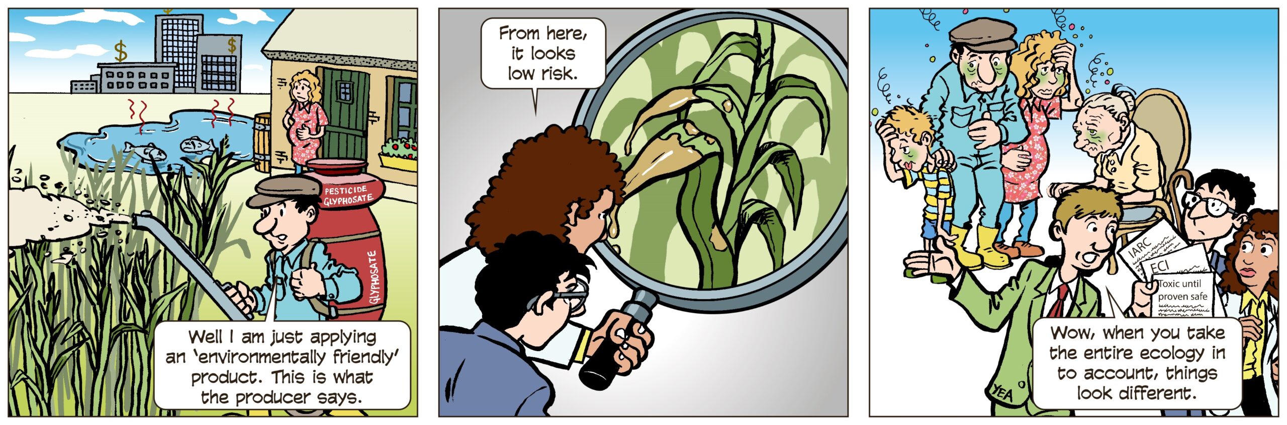
In dealing with the health and ecological harms from chemical exposures, regulators have been behind the curve, playing a game of eternal catch-up. For every after-the-fact regulated chemical, the chemical industry has another stack of chemicals on the shelf ready to deploy to markets. Such is the case with Monsanto’s (now Bayer) glyphosate, which exposed as associated with Non-Hodgkin’s Lymphoma, has brought out the even more deadly pesticide dicamba as its replacement. Or, DuPont’s replacement of one PFAS[12] product with another – the endocrine-disrupting ‘forever’ chemicals used in GoreTex jackets and Teflon pans have simply switched a molecule in their organofluorine polymers – we now have GenX instead of PFOAs (Perfluorooctanoic acids, also known as C-8). Such unfortunate substitutions cannot be claimed as victories.
To combat the current Sisyphusian role of chemical regulatory agencies playing “chemical whack-a-mole,” chemical researchers have begun calling for a toxic-until-proven-safe rather than safe-until-proven-toxic paradigm.[13] Many of the chemicals we use currently are shortcuts – they allow unsustainable lives at the expense of others—past, present, and future, human and more-than-human. To get to equity and sustainability, we need to rethink the use, purpose, and place of chemicals in our material environments.
A truly ‘green’ (biocompatible) chemistry needs a toxic-until-proven-safe framework, working to eliminate the worst known chemicals (especially those that cause reproductive health effects and endocrine disrupters, like organophosphates). Additionally, we need to thoroughly reconsider the trade-offs we’ve implicitly accepted for chemical modernism. If we’re to escape the confines of chemical colonialism, we can’t expect to simply switch out different chemicals in an industrial ecology run on toxins based in inequality.
Biomimicry and indigenous materials science needs to be mainstreamed and funded, in order to find nontoxic ways not just of replacing existing toxic chemicals, but to modulate our material environments to not rely on quick and easy disposable chemical-fueled solutions.
References
[1] Fabian Scheidler, The End of the Megamachine (Ridgefield, CT: Zero Books, 2020), 80.
[3] Danielle S. Allen, Talking to Strangers: Anxieties of Citizenship since Brown v. Board of Education (Chicago: Univ. of Chicago Press, 2004).
[4] Carolyn Merchant, The Death of Nature: Women, Ecology, and the Scientific Revolution (New York: Harper & Row, 1980), 38.
[5] Timo Maran, “Enchantment of the Past and Semiocide. Remembering Ivar Puura,” Sign Systems Studies 41, no. 1 (May 17, 2013), https://doi.org/10.12697/SSS.2013.41.1.09.
[6] John M. Gowdy and Carl N. McDaniel, “The Physical Destruction of Nauru: An Example of Weak Sustainability,” Land Economics 75, no. 2 (May 1999): 333, https://doi.org/10.2307/3147015.
[7] Robert Proctor, “Agnotology: A Missing Term to Describe the Cultural Production of Ignorance (and Its Study),” in Agnotology: The Making and Unmaking of Ignorance, ed. Robert Proctor and Londa L. Schiebinger (Stanford, Calif.: Stanford University Press, 2008), 7.
[8] Lawrence Summers, “The Lawrence Summers Memo,” The Whirled Bank Group, December 12, 1991, http://www.whirledbank.org/ourwords/summers.html.
[9] Joseph Henrich, Steven J. Heine, and Ara Norenzayan, “The Weirdest People in the World?,” Behavioral and Brain Sciences 33, no. 2–3 (June 2010): 61–83, https://doi.org/10.1017/S0140525X0999152X.
[10] Leah Aronowsky, “Gas Guzzling Gaia, or: A Prehistory of Climate Change Denialism,” Critical Inquiry 47, no. 2 (January 2, 2021): 306–27, https://doi.org/10.1086/712129; Stan Cox, The Green New Deal and Beyond: Ending the Climate Emergency While We Still Can (San Francisco, CA: City Lights Publishers, 2020).
[11] Yogi Hale Hendlin, “Surveying the Chemical Anthropocene: Chemical Imaginaries and the Politics of Defining Toxicity,” Environment and Society 12, no. 1 (September 1, 2021): 181–202, https://doi.org/10.3167/ares.2021.120111.
[13] Alessandra Arcuri and Yogi Hale Hendlin, “The Chemical Anthropocene: Glyphosate as a Case Study of Pesticide Exposures,” King’s Law Journal, September 19, 2019, 1–20, https://doi.org/10.1080/09615768.2019.1645436.
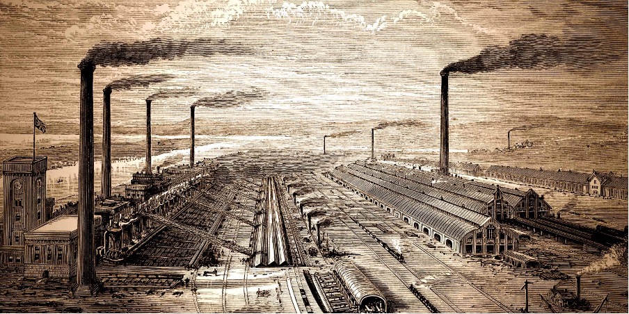
Cover image: “The Iron and Steel Works, Barrow.” Washington Post illustration; iStockphoto
Yogi Hale Hendlin’s work draws on environmental philosophy, especially decolonial kinds, and public health policy, including the corporate determinants of health, to dismantle industrial epidemics. Hendlin is an assistant professor at Erasmus University Rotterdam in the Erasmus School of Philosophy, and Dynamics of Inclusive Prosperity Initiative, as well as Research Associate in the University of California, San Francisco’s Environmental Health Initiative. As Editor-in-Chief of the journal Biosemiotics, Hendlin explores the biological basis for redesigning human systems biomimetically rather than extractively, benefitting both human and more-than-human nature. www.yogihendlin.com
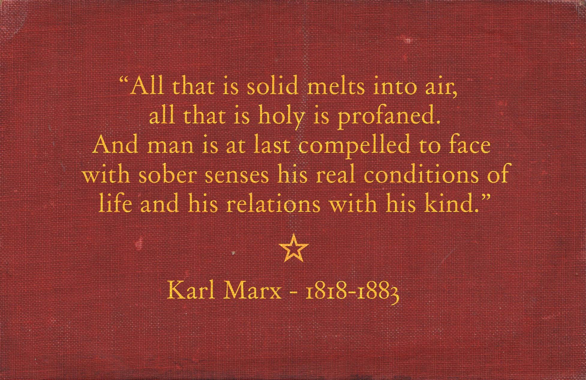
All that is solid melts into air, all that is holy is profaned, and man is at last compelled to face with sober senses, his real conditions of life, and his relations with his kind.
Marx and Engel, the Communist Manifesto
When my world evaporated into exhaustion with Long Covid, I found myself pondering Marshall Berman’s (1988) insight from his eponymous book, “To be modern is to find ourselves in an environment that promises us adventure, power, joy, growth, transformation of ourselves and the world—and at the same time, that threatens to destroy everything we have, everything we know, everything we are” (15). While modernity brought exhilarating emancipation of education, movement, and identity, it also eroded collective safety nets. Albeit “freed” from the constraints of custom, individuals became vulnerable in new ways to accidents, crashes, hazards, or disasters—be they natural, technological, economic. . . or viral. As public health authorities unfurled confusing, if not erratic, directives about mask mandates and vaccination priorities over the last two years, we learned once again how utterly dependent our lives are to opaque bureaucratic institutions and a standardized “utopia of rules” (Graeber 2015). In these contexts, things tend to fall apart (Achebe 1959).
A disaster is said to be a social construct because its sudden occurrence disrupts the functioning of a society, causing human, material, economic, cultural and environmental losses that exceed the community’s ability to cope using its own resources. Thus, any natural hazard that leads to loss of human lives and property and damages the surrounding resources and non-human entities can be called a disaster (Wisner et al, 2014; Nadiruzzamam, 2016).
Historical evidence has shown that the region of Sundarbans has faced cyclones and their never-ending fury through time. The oldest recorded evidence is from 1582 AD, when a cyclone swept over Bakergunje, in Bangladesh’s Barishal district (part of Bangladesh Sundarbans), causing a loss of 200,000 lives, hectares of farmland, and many cattle. O’ Malley, in his Gazetteer of 24 Parganas (1914), asserts that there is “no safeguarding against the sudden fury of a cyclone, and its record shows that, though they occur at irregular intervals, these violent storms are far more destructive of life and property than either droughts or floods” (Biswas, 2020).
The Indonesian president made this promise amid the fire and smoke haze disaster in September 2015. He was troubled by the fact that the 2015 fires severely impacted the nation’s environment, economy, and politics. Soon after, he established the Badan Restorasi Gambut (BRG, or Peatland Restoration Agency),[2] a new institution with the main purpose of restoring the degraded environment. After enforcing coercive approaches for decades, this moment was the very first time the Indonesian government took a formal, coherent, and scientific-driven approach to tackle fire-related problems. One striking maneuver of the BRG was the way it created thousands of infrastructures as part of its fire governance. These were the facilities BRG expects Indigenous communities like Ngaju people in Central Kalimantan to operate and maintain to achieve an ideal environmental future—to fulfill the promise of the government.
Seawater desalination, the industrial production of drinking water from the ocean, is a practice of increasingly intense interest to thirsty cities across the globe. And why not? It promises the ability to provide a reliable water source that is (seemingly) invulnerable to climate change. What is more, the market is responding, with a global estimated value of roughly $18 billion[1] (c.f., Swyngedouw and Williams 2016). And there is significant expected growth, up to $32 billion (that’s about half the estimated size of the wind industry),[2] in the next four years.
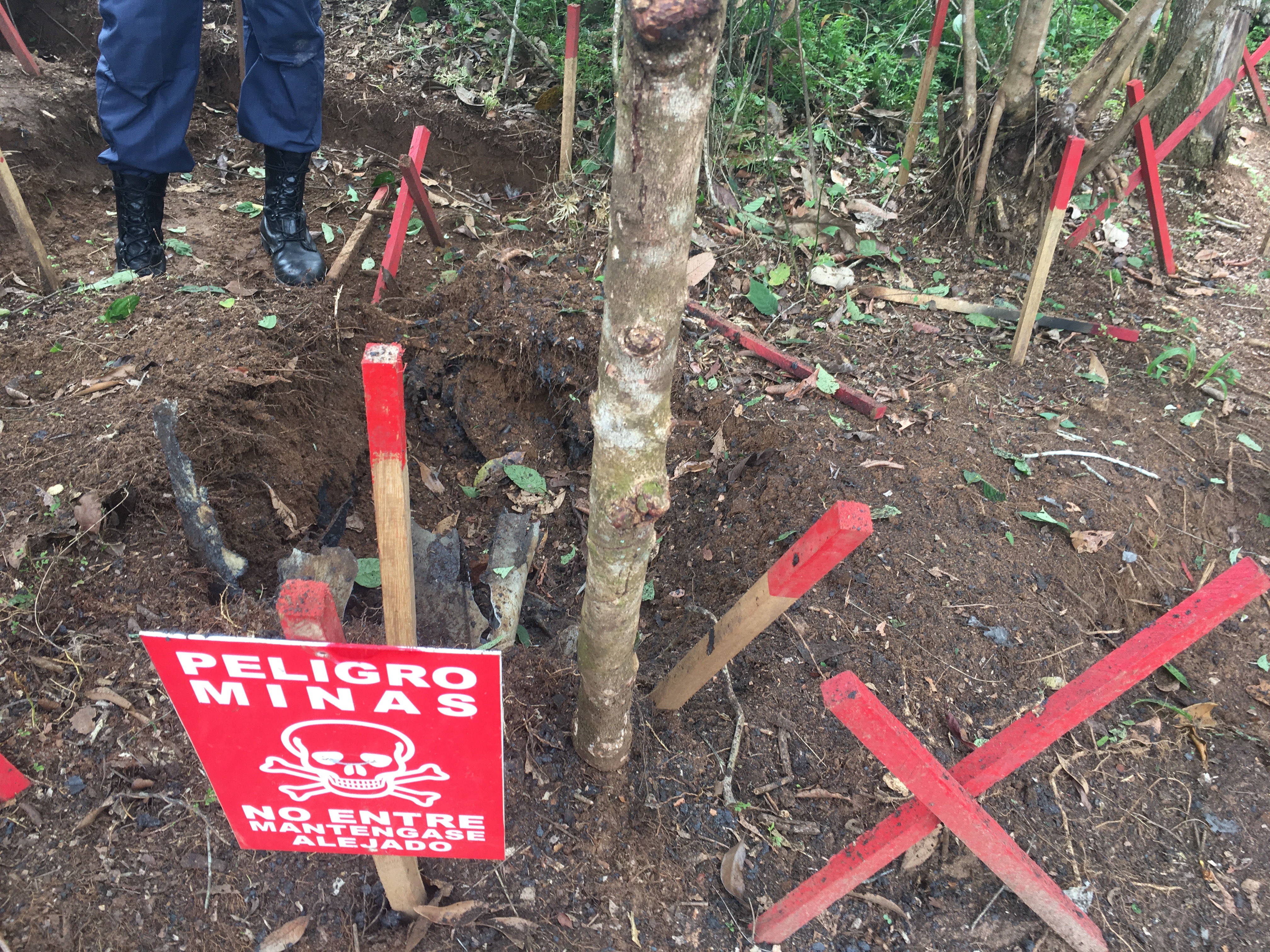
A line of ants walking throughout a 5-liter white plastic recipient, wrapped in black trash bags and trespassed by roots, was my first experience with a landmine. This artifact enmeshed into nature and co-produced a toxic wilderness.
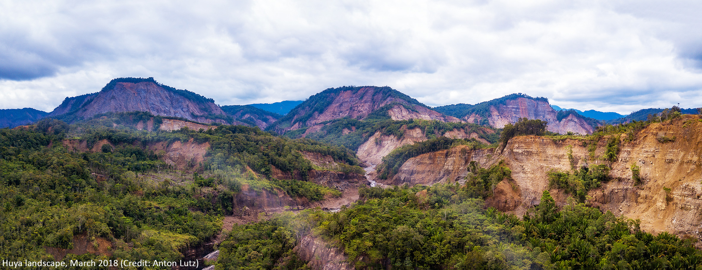
In a previous post to EnviroSociety we described the immediate impacts of a huge earthquake on Edolo people of Papua New Guinea. At the time we wrote, the people were in desperate straits, with minimal access to government services and reliant on support from several mission-connected NGOs. In this sequel, three years later, we write of ways in which the people themselves have been re-establishing a hold on what had been, and in places still remains, a shattered landscape.
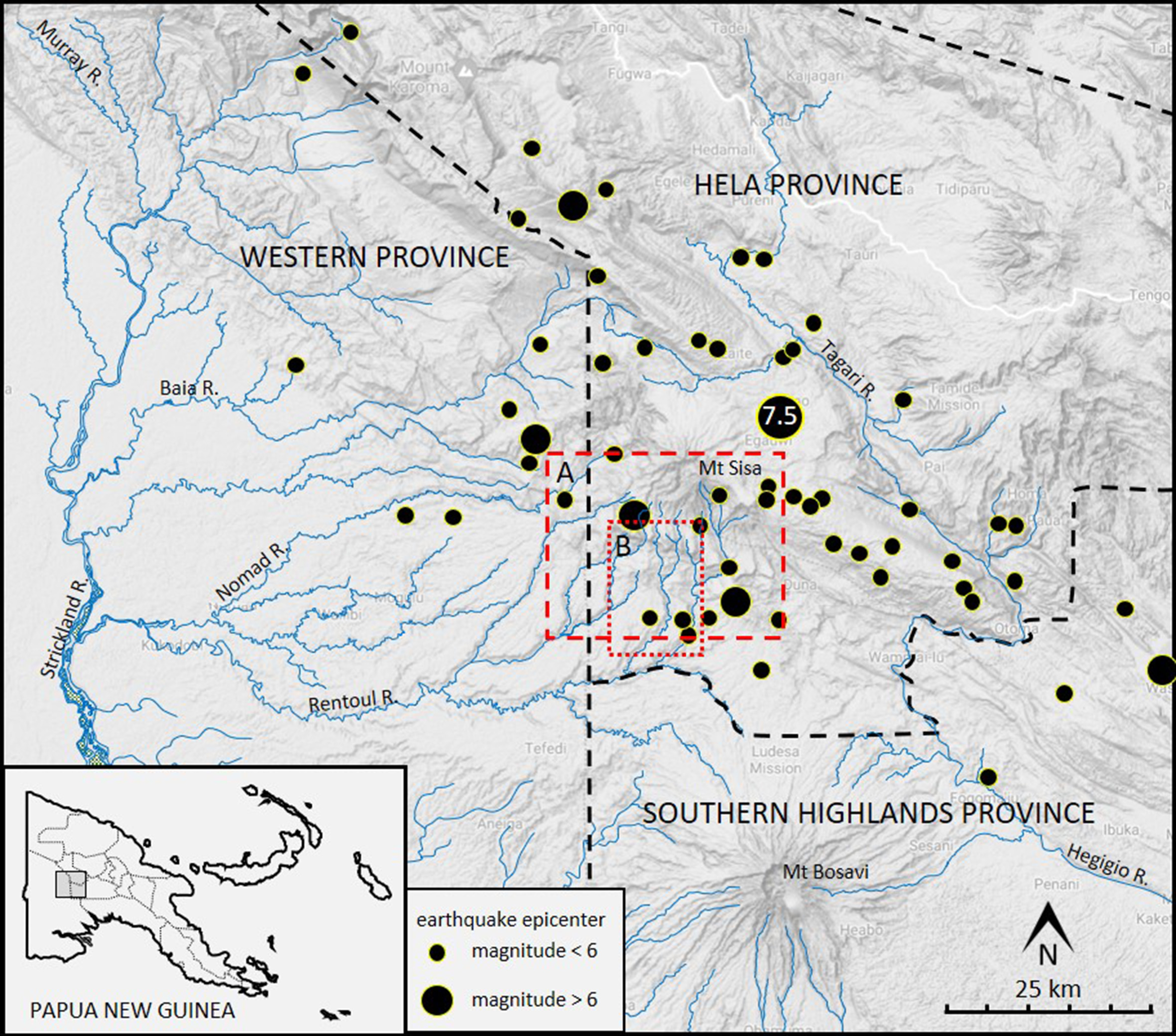
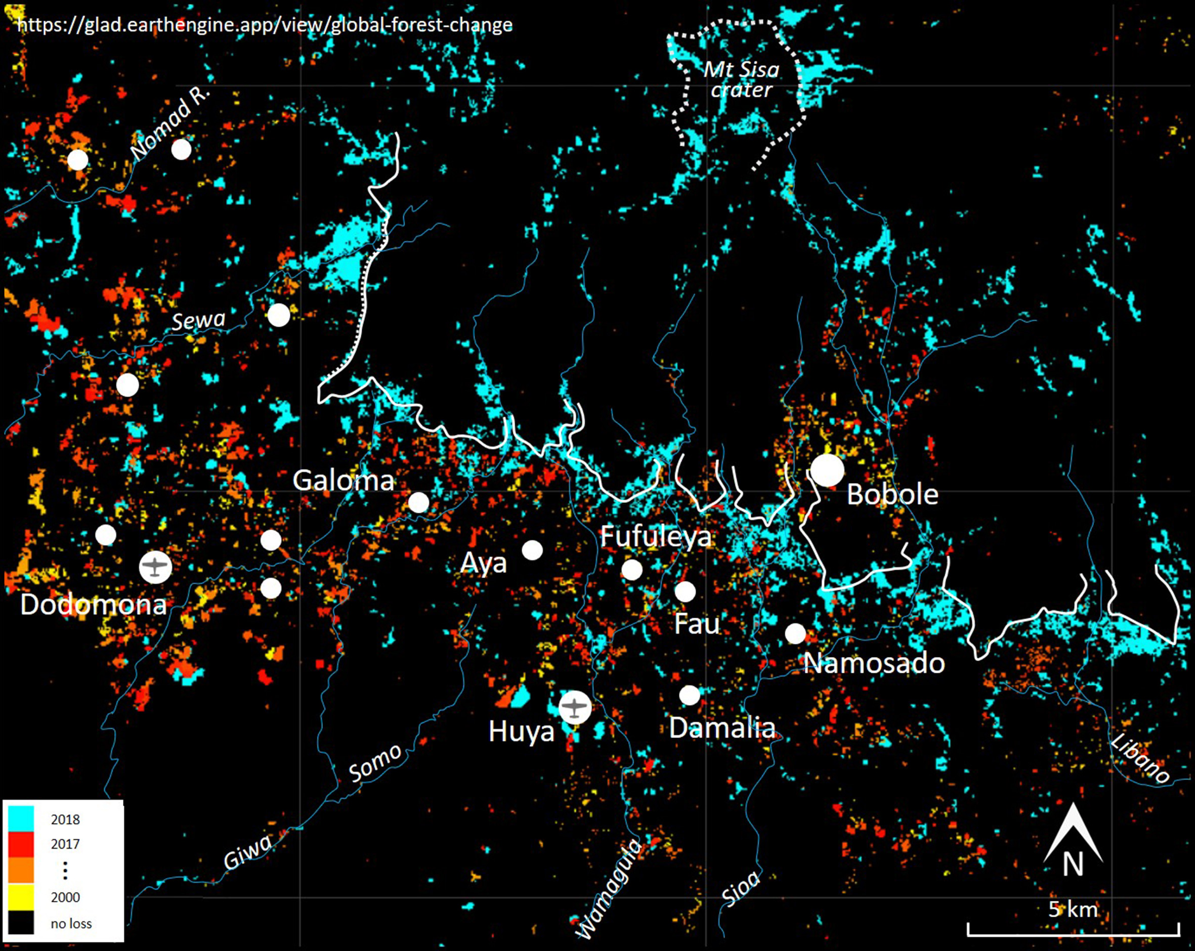
Through the early months of 2018, a magnitude 7.5 earthquake, and a swarm of subsequent shocks, had devastating impacts on the land, rivers and people on and near Mount Sisa, in Hela Province, Papua New Guinea (Figure 1, Zahirovic et al. 2018). Edolo-speaking people living on the steep southern slopes of that extinct volcano were seriously affected (Dwyer and Minnegal 2018). Some were buried under huge landslides (Figure 2). Most abandoned their small villages (Figure 3) and fled to either Dodomona or Huya, the only places with airstrips and radio connection to the outside world. At these two villages populations increased from a few hundred men, women and children to one and a half thousand.
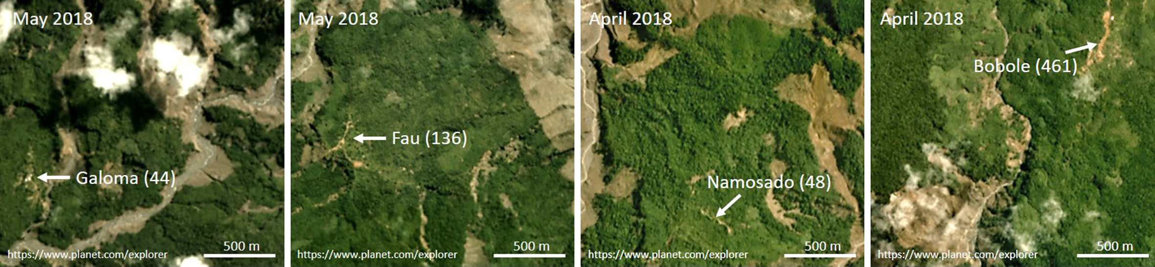
Figure 1. Map of portion of Papua New Guinea showing epicenter of the magnitude 7.5 February 2018 earthquake and epicenters of some of the subsequent swarm of earthquakes. Epicenter locations are from Mahoney et al. (2021). The area outlined as A is shown in Figure 2; the area outlined as B is shown in Figure 5.Figure 2. Loss of forest cover in the Mount Sisa area in 2018 and earlier. The white line marks an escarpment that spans altitudes of about 1,000 to 1,200 m ASL. Locations of primary villages are shown as white dots. Most areas colored blue lost forest cover as a result of landslides. Most of those close to Huya, however, are areas cleared to make gardens after the first earthquake.Figure 3. Satellite imagery showing landslides in the vicinity of the villages of Galoma, Fau, Namosado and Bobole. On each figure, an estimate of pre-earthquake population size at that village is shown in parentheses.
Nearly all food of Edolo people comes from a diverse array of practices that include gardening, arboriculture, sago processing, pig husbandry and hunting (Kelly 1977: 32-64, Dwyer 1990). Access to store-bought foods, though desired, is limited and intermittent. In 2018, the rapid increase in population at just two locations meant that local food supplies were overwhelmed. For months, people needed supplementary support from outside relief organizations (ADRA 2018).
Three years have elapsed since those earthquakes. Here we draw on satellite imagery to describe responses by Edolo people who lived at, or relocated to, Huya.1 Many people made gardens south of Huya, in an area that had seen little use over several decades. For them, this shift in the geography of garden locations may have far-reaching effects on overall subsistence practices and, indeed, on concomitant social practices and health.
Huya
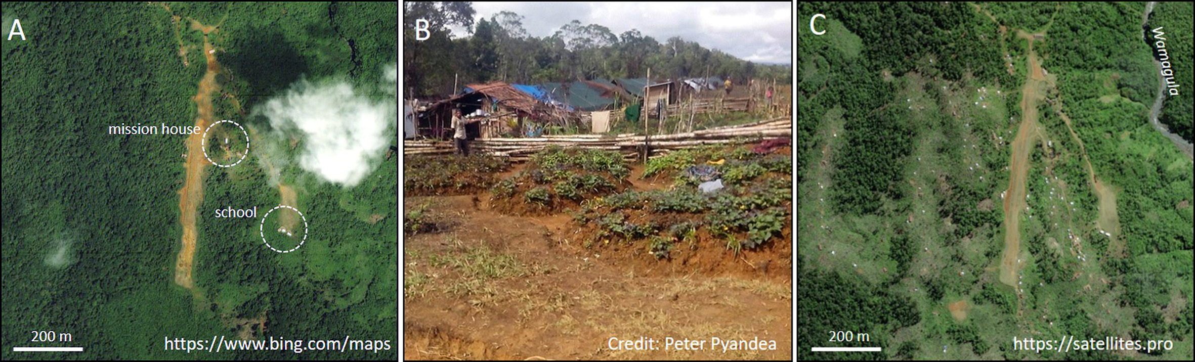
The Huya airstrip was made over a period of 10 years. The first plane landed there in early 2003 and, since then, it has been served by planes associated with Summer Institute of Linguistics and Mission Aviation Fellowship. By 2016, the population at Huya was 192 men, women and children.
The first earthquake struck on 26 February 2018. Through the next weeks men, women and children from Galoma, Aya, Fufuleya, Fau, Damalia, Namosado and Bobole (Figure 2) sought refuge at Huya. Many built temporary houses alongside the airstrip and made small garden plots near these (Figure 4B). Through the next two years the refugees built more than 100 houses on ridgetops near to, and immediately west of, the airstrip (Figure 4C).
Figure 4. A Huya airstrip and surrounds before the earthquake of February 2018. Houses of Huya residents are visible at the northern end of the airstrip close to a major walking track. B. Refugee houses and household gardens established near the airstrip by May 2018. C. Huya airstrip and surrounds in about May 2019 showing houses built by refugees. Most houses are roofed with tarpaulins that were provided as emergency aid. Others are thatched with fronds from sago palms.
The location of gardens, 2018
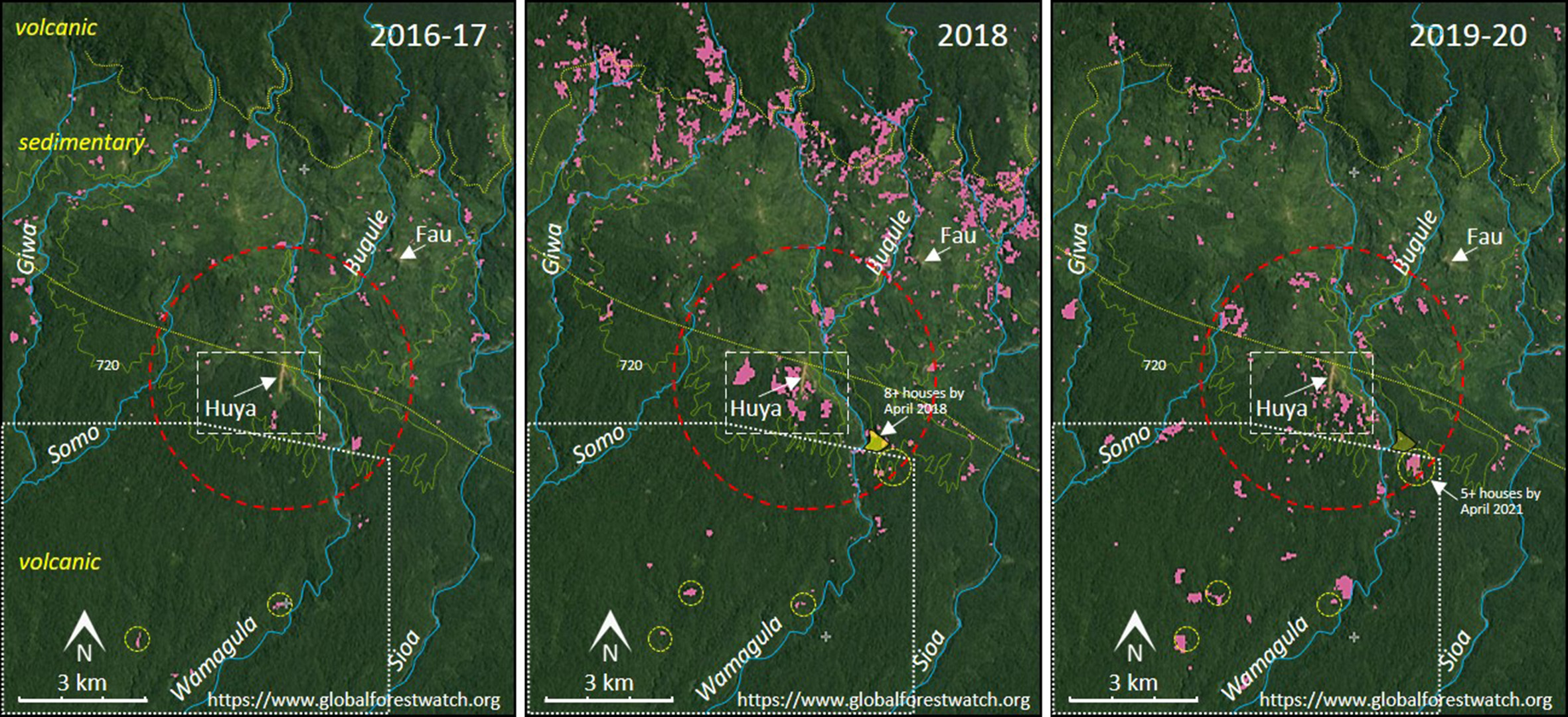
Soon after displaced people arrived at Huya they commenced fencing and felling areas of forest to establish gardens that were secure from both wild and domestic pigs. In 2018, people felled 62 ha in an area of approximately 525 ha near Huya (Figure 5). In 2016-17, they had felled only 2 and 5 ha, respectively, in the same area.
Figure 5. Loss of forest cover (pink) between Giwa River in the west and Sioa River in the east. Separate figures are provided for 2016-17, 2018 and 2019-20. The 720 m contour is shown; the summit of Mount Sisa is at 2,689 m ASL. North and south of Huya, soils overlie volcanic rock; between these is a zone where soils overlie sedimentary rocks. The lighter green coloring of much of this intervening zone is because it has been used extensively for gardening and is covered in regrowth forest. Most forest cover loss in 2018 was caused by earthquakes with huge landslides along the entire length of the escarpment. There were additional landslides in 2019. The dashed red circle has a radius of 3 km. The circled areas in the lowest section of the figures (altitude 550-650 m) enclose gardens, subsequent extensions to those gardens and, by at least 2019, identifiable houses. (Geological detail after Mahoney et al., 2021.)
In the years 2014 to 2017, the area of forest cover loss associated with the villages of Galoma, Aya, Fufuleya, Fau, Damalia, Namosado and Huya was equivalent to 0.085 hectares per person per year for approximately 950 people. Virtually all this will have been the result of clearing forest to make gardens. However, when village sites remain in much the same place for a decade or more some gardens, made in relatively young regrowth, will not be detected as ‘forest cover loss’ in satellite imagery. With allowance for complications of this sort we think that the 62 hectares felled near Huya in 2018 will have provisioned 400 or more people through a 12-month period. This effort, therefore, reflects a capacity of Edolo people to respond relatively rapidly and effectively to disastrous circumstances.
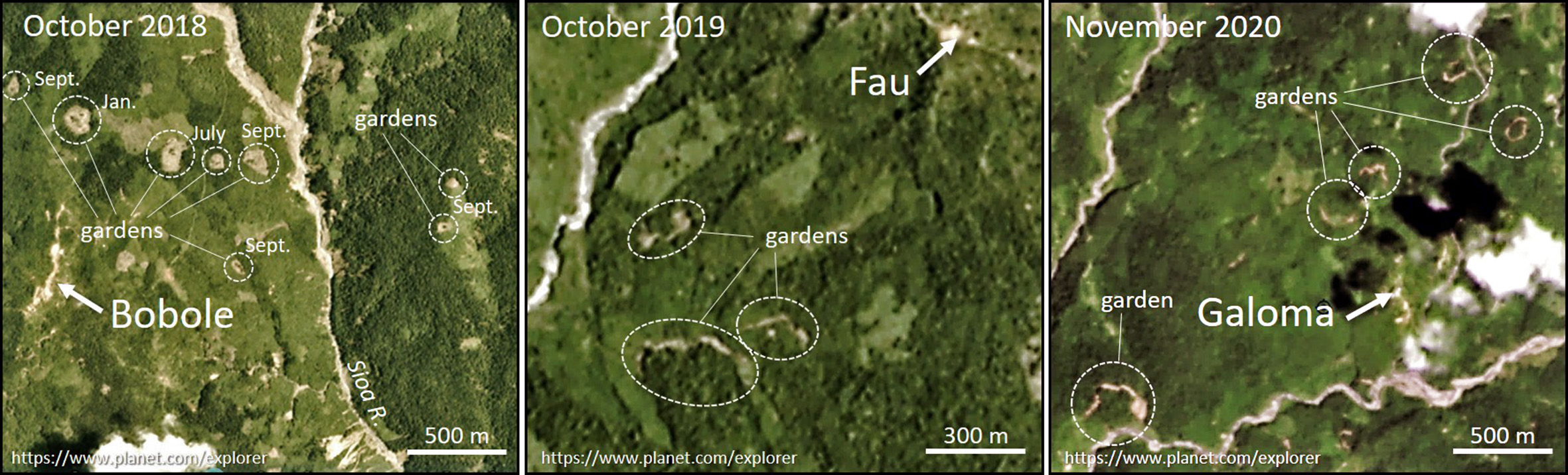
By late 2018 at least eight small gardens had been cut into advanced regrowth near Bobole (Figure 6). Some people either remained at Bobole or returned there soon after the earthquake. An early return is not unexpected. Many more people lived at Bobole than at the other communities which relocated to Huya. Further, for more than five decades, exchanges of goods and people between Edolo and the highlands has been through Bobole and it continues to be a focal way-station for highlanders who walk to and from Kiunga, more than 200 km to the west, to explore prospects for employment at the Ok Tedi mine, to engage in alluvial mining or to exchange marijuana for guns with people from the Indonesian province of Papua.
The location of gardens, 2019-20
In 2019-20 people commenced clearing forest to make gardens at greater distances from Huya. In these two years they felled only 26 and 12 ha respectively in the area of 525 ha near Huya but felled an additional 44 (2019) and 39 (2020) hectares within 3 km of the airstrip. Much of this was to the north of Huya (Figure 5).
By October 2019 some forest areas south of Fau were being fenced (Figure 6) but, other than at Bobole, it is not until late 2020 that we detect unambiguous signs of substantial areas of garden being prepared near previously abandoned villages. This was most striking near Galoma and indicates resettlement of this area.
Figure 6. Satellite images showing early felling and perimeter fencing in the preparation of post-earthquake gardens near Bobole, Fau and Galoma. For Bobole the month each garden was commenced is indicated. These images of gardens in progress conform to patterns seen at Bobole in the late 1970s (Dwyer 1990: 32-4).
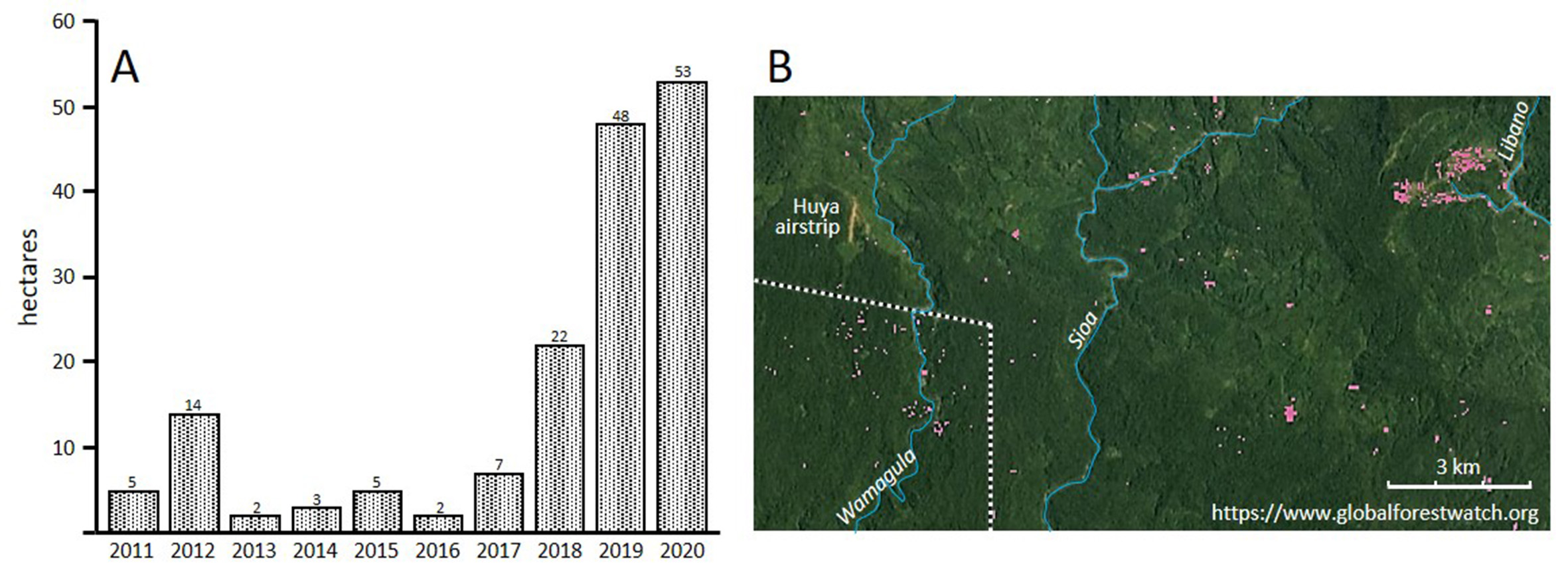
In 2019 and 2020, however, people made more extensive use of forest areas south of Huya than they had done in the previous decade. In Figure 5 the dotted white line encloses an area of 5.64 kha south of Huya. Forest cover loss from this area averaged 5.43 ha/year for the period 2011 to 2017 and, thereafter, increases from 22 ha in 2018 to 48 and 53 ha in, respectively, 2019 and 2020 (Figure 7). The 53 ha of garden in 2020 may have been enough to satisfy much of the agricultural requirements of 300 or more people across 12 months. It appears that many of the families who were displaced to Huya chose to relocate to areas that had been least damaged by landslides.
Figure 7. A. Forest cover loss in an area of 5.64 kha south of Huya (see Figure 5). B. Forest cover loss (pink) from an area east and south of Huya in 2012. The comparatively high value for forest cover loss in 2012 seen in the histogram is attributed to extensive windfall in the northeast corner of the area outlined in Figure 5 by a dotted white line. In the same year a substantial landslide removed forest cover where the Libano River cuts through the escarpment.
Concluding remarks
Three years after the earthquakes of 2018, the spatial patterning of Etolo subsistence gardens does not yet resemble earlier patterns. By late 2020 gardens had been made in the vicinity of most former villages but many people remained at Huya and some, probably several hundred, had redirected gardening effort to the south, well away from the escarpment near which they had lived before. For these people, long-term outcomes may be significant.
The 1974 Sisa topographic map (PNG 1:100,000 Topographic Survey, Sheet 7485, Series T683), compiled from aerial photography and colonial government patrol reports, does not show a single garden site, area of regrowth or house between 250 and 760 m ASL in the area between Giwa and Sioa rivers. Thus, some Edolo people are currently establishing a foothold on land that has been free from residential impacts for at least five decades.
To make gardens in this area people will be felling trees in primary forest rather than advanced regrowth. This will entail considerably more effort for each hectare of garden that is made. They will be planting crops in soils that overlie volcanic rock rather than sedimentary rock and this is likely to influence patterns of both crop selection and garden production (cf. Sillitoe 1998). At the lower altitudes, conditions will be less favourable than before for sweet potato and more favourable for taro. Sago palms, fish and wild pigs will be more accessible than before but because the forested slopes of Mount Sisa, north of the escarpment, will be further from living places opportunities to hunt and trap game mammals will be reduced (Dwyer 1990: 69-84). At lower altitudes, too, exposure to malaria will be increased. All these impacts will, ultimately, call for modifications to ways in which people schedule subsistence tasks and allocate tasks between men and women (Dwyer 1986).
To the extent that relocation to the south is sustained, people may well be tempted to redirect some social contacts to Kaluli-speaking communities who live south of Sioa River, and who, for many years, have been better placed for access to the outside world than those who live on the precarious slopes of Mount Sisa.
Coda: or a little of what we don’t know
Satellite imagery has allowed interpretations of some post-earthquake gardening practices by Edolo people who live in the vicinity of Huya. Those images, however, do not provide any information about impacts on three other important practices – sago processing, marita pandanus (P. conoideus) orcharding, and pig husbandry.
North of Huya, some groves of sago palms and some pandanus orchards will have been destroyed by landslides.2 Sago palms will be available at lower altitudes though here, for newcomers, issues of ownership will complicate access. Marita, however, does not grow wild and will not be immediately available in forests south of Huya. In 1979-80, 109 people at Bobole maintained about 10 ha of pandanus orchards. The oily fruit was abundant from November to May (Dwyer 1990: 61-63). It is likely that, by late 2018, people who had relocated to Huya made excursions to their orchards to harvest fruit. But for those who settle to the south it will be three or more years before newly planted marita bear fruit.
As is common elsewhere in Papua New Guinea, pigs are important to Edolo as a feast food and in many social exchanges. In the late 1960s and 1970s the ratio of domestic pigs to people at Gabulusado (since relocated to Aya) and Bobole approached parity and most of the animals were allowed to roam freely through areas of regrowth (Kelly 1988, Dwyer 1990: 55-61). When people moved to Huya immediately after the earthquake, women may well have carried small piglets with them but most animals will have been left behind. Some domestic pigs were probably killed in landslides, others may have become feral. Pigs, however, are highly valued. It is likely that as refugees became established at Huya, and anxiety levels subsided, some visited former living places to check on the well-being of surviving pigs. Certainly, in the months after the earthquake some people travelled out from Huya to harvest gardens and retrieve abandoned chickens (Jan Gossner, pers. comm.).
In future post-pandemic times, it may be possible to ground-truth, revise and enlarge upon these observations of ways in which Edolo people are responding to a devastating event in their lives. This would have positive outcomes both in identifying ongoing needs of those people and in addressing questions about the relative success, over a span of years, of practices people adopt when seeking a path to secure living after experiencing extreme perturbation.
Notes
Thanks to Jan Gossner, Sally Lloyd, Anton Lutz, Luke Mahoney, Peter Pyandea and Russ Stephenson for valuable help and information.
1. ‘Global Forest Change’ (https://glad.earthengine.app/view/global-forest-change) provides annual depictions of forest cover loss ‘defined as a stand-replacement disturbance, or a change from a forest to non-forest state’ (Hansen et al. 2013). In regions dominated by rainforest, such as those where Edolo live, most forest cover loss is the result of clearing for gardens, village sites and airstrips or landslides, storm-related tree fall and, less often, fire. ‘Global Forest Watch’ (https://www.globalforestwatch.org/) is a companion site that allows forest cover loss to be tracked and, for defined areas, quantified on a year-by-year basis or, cumulatively, over a series of years. Planet Explorer (https://www.planet.com/explorer/) provides monthly collations of satellite imagery that for the Mount Sisa area date back to 2016. These allow cross-referencing when interpreting imagery provided by Global Forest Change, Global Forest Watch, Google Earth, Bing Maps and Satellites.pro. We have drawn on all these resources in the present analyses.
2. Many sago palms are visible below the collapsed escarpment on the righthand side of the photograph that heads this article.
References
ADRA (Adventist Development Relief Agency) 2018. “ADRA responds to PNG earthquake.” https://www.adra.org.au/adra-responds-to-png-earthquake/
Dwyer, Peter D. 1986. “Living with Rainforest: The Human Dimension”, pp. 342-67 in J. Kikkawa and D. Anderson (eds), Community Ecology: Pattern and Process. Blackwell Scientific Publications, Melbourne.
Dwyer, Peter D. 1990. The Pigs That Ate the Garden: A Human Ecology from Papua New Guinea. Ann Abor: University of Michigan Press.
Dwyer, Peter D. and Monica Minnegal. 2018. “Refugees on their own Land. Edolo People, Land and Earthquakes.” EnviroSociety, 9 June 2018. www.envirosociety.org/2018/06/refugees-on-their-own-land-edolo-people-land-and-earthquakes
Hansen, M. C., P. V. Potapov, R. Moore, M. Hancher, S. A. Turubanova, A. Tyukavina, D. Thau, S. V. Stehman, S. J. Goetz, T. R. Loveland, A. Kommareddy, A. Egorov, L. Chini, C. O. Justice and J. R. G. Townshend (2013) “High-Resolution Global Maps of 21st-Century Forest Cover Change.” Science 342 (6160): 850-53.
Kelly, Raymond C. 1977. Etoro Social Structure: A Study in Structural Contradiction. Ann Arbor: University of Michigan Press.
Kelly, Raymond C. 1988. ‘Etoro Suidology: A Reassessment of the Pig’s Role in the Prehistory and Comparative Ethnology of New Guinea’, pp. 111-86 in J. F. Weiner (ed.), Mountain Papuans: Historical and Comparative Perspectives from New Guinea Fringe Highlands Societies. Ami Arbor: University of Michigan Press.
Mahoney, Luke, Richard Stanaway, Sandra McLaren, Kevin Hill and Eric Bergman (2021) “The 2018 Mw 7.5 Highlands Earthquake in Papua New Guinea: Implications for Structural Style in an Active Fold and Thrust belt.” Tectonics https://doi.org/10.1029/2020TC006667
Sillitoe, Paul 1998. “Knowing the Land. Soil and Land Resource Evaluation and Indigenous Knowledge.” Soil Use and Management 14: 188-193.
Zahirovic, Sabin, Gilles Brocard, John Connell, and Romain Beucher 2018. “Aftershocks Hit Papua New Guinea as it Recovers from a Remote Major Earthquake.” The Conversation, 9 April.
Peter Dwyer is Honorary Senior Fellow in the School of Geography, Earth & Atmospheric Sciences at the University of Melbourne. Monica Minnegal is Associate Professor of anthropology in the School of Social and Political Sciences at the University of Melbourne. Since 1986, they have conducted research among Kubo, Febi, and Bedamuni people of Western Province, Papua New Guinea, with a particular emphasis on social change and, most recently, impacts of the PNG LNG project on people’s lives. Their book Navigating the Future: An Ethnography of Change in Papua New Guinea was published in 2017 by Australian National University Press.