In a previous post to EnviroSociety we described the immediate impacts of a huge earthquake on Edolo people of Papua New Guinea. At the time we wrote, the people were in desperate straits, with minimal access to government services and reliant on support from several mission-connected NGOs. In this sequel, three years later, we write of ways in which the people themselves have been re-establishing a hold on what had been, and in places still remains, a shattered landscape.
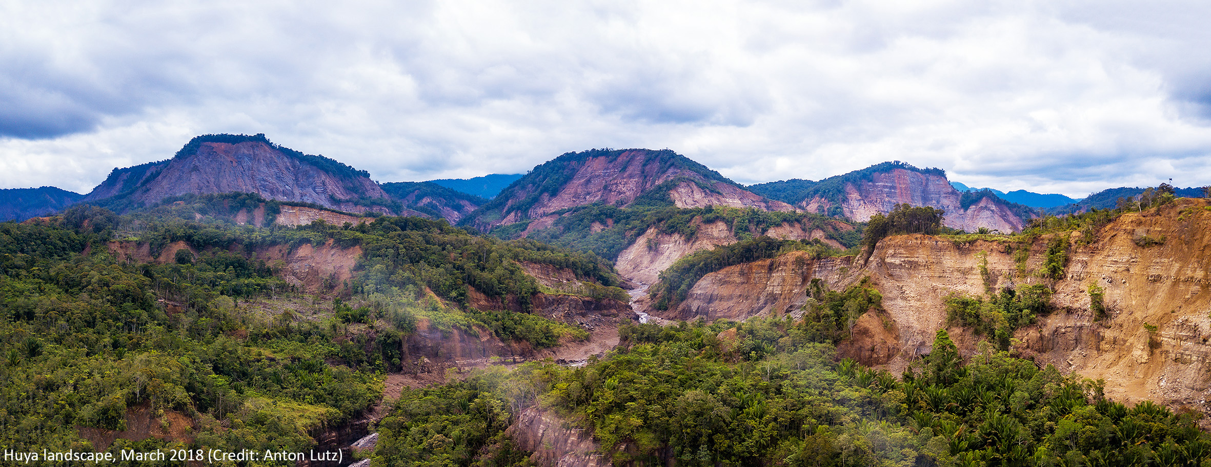
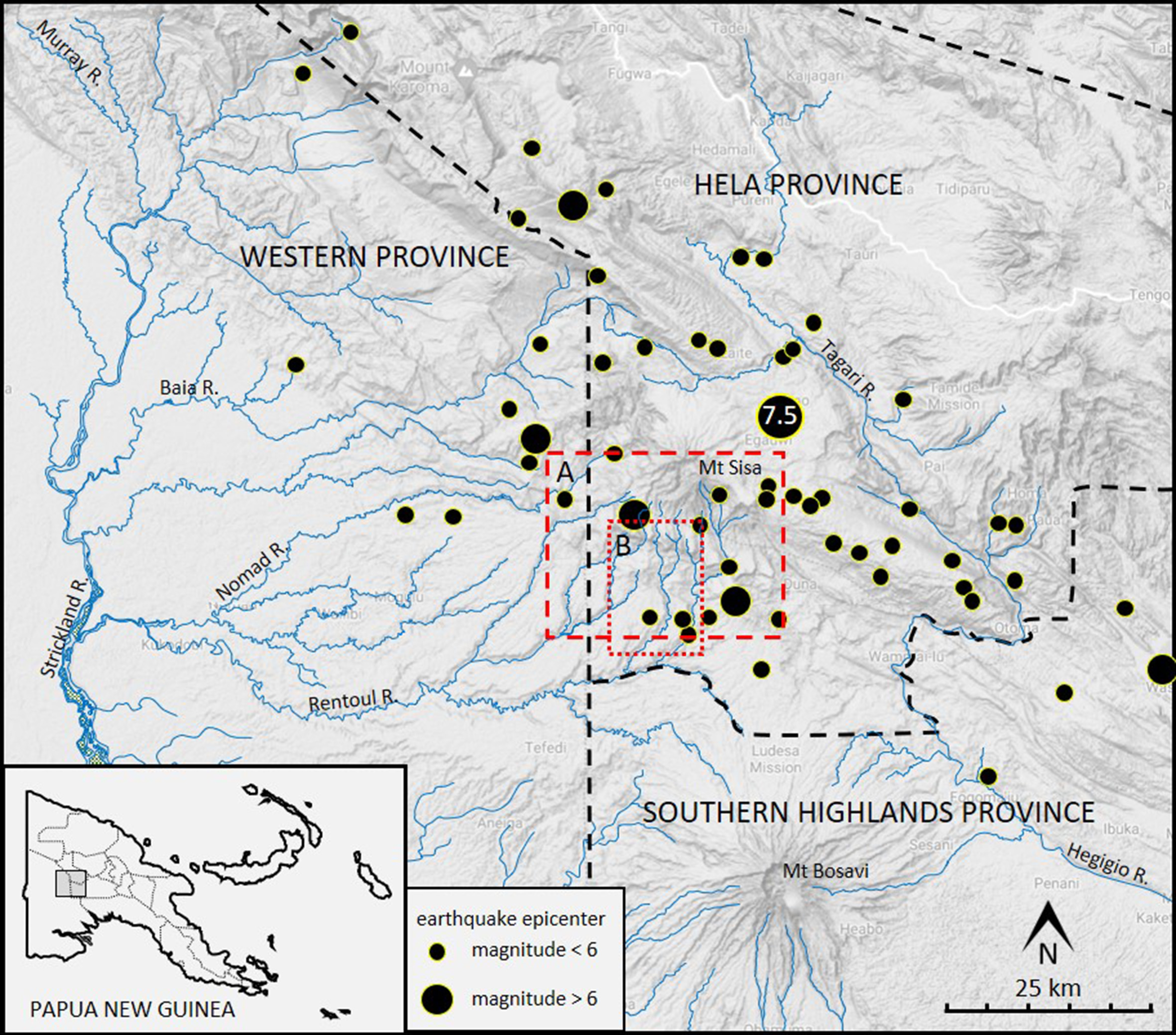
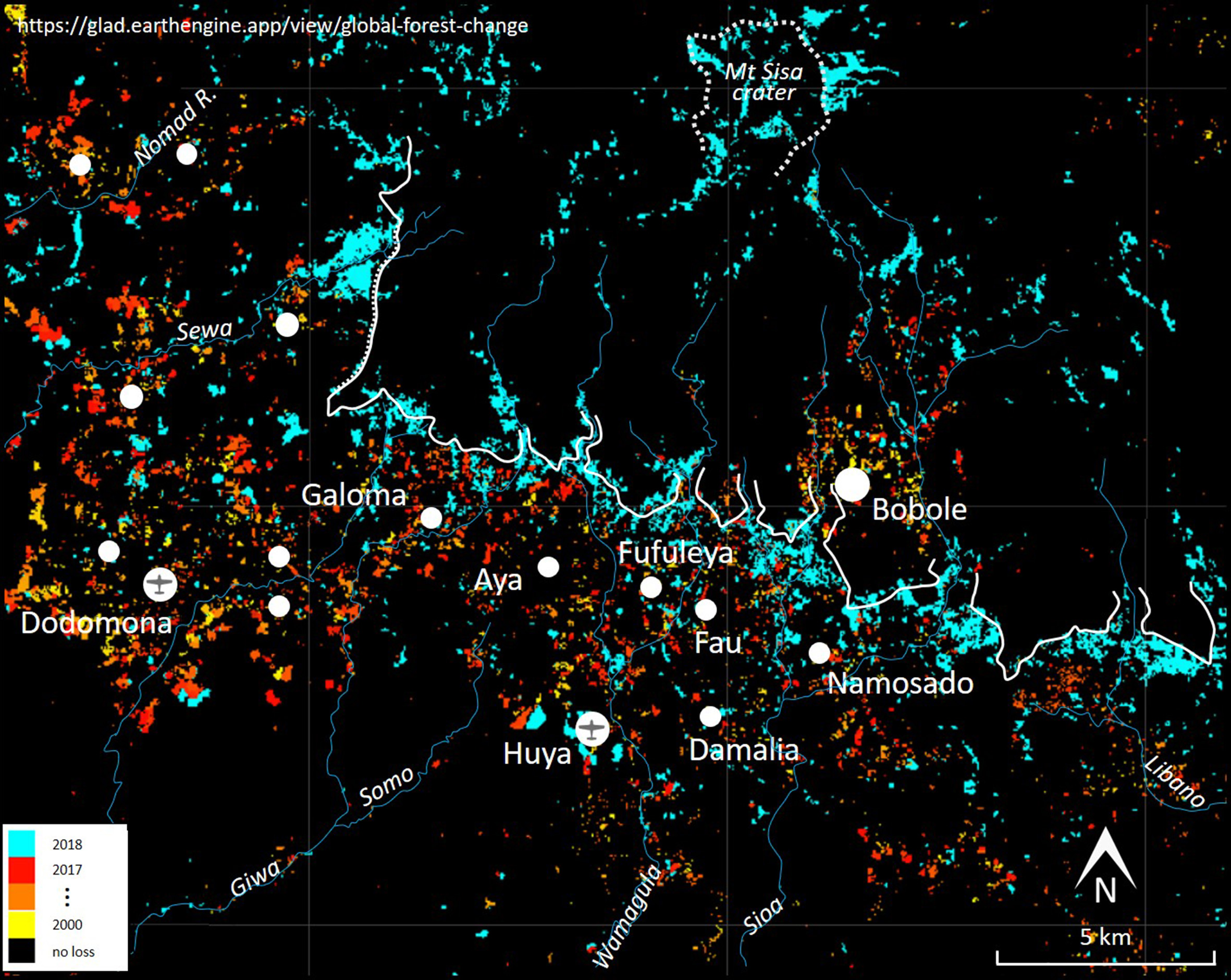
Through the early months of 2018, a magnitude 7.5 earthquake, and a swarm of subsequent shocks, had devastating impacts on the land, rivers and people on and near Mount Sisa, in Hela Province, Papua New Guinea (Figure 1, Zahirovic et al. 2018). Edolo-speaking people living on the steep southern slopes of that extinct volcano were seriously affected (Dwyer and Minnegal 2018). Some were buried under huge landslides (Figure 2). Most abandoned their small villages (Figure 3) and fled to either Dodomona or Huya, the only places with airstrips and radio connection to the outside world. At these two villages populations increased from a few hundred men, women and children to one and a half thousand.
Nearly all food of Edolo people comes from a diverse array of practices that include gardening, arboriculture, sago processing, pig husbandry and hunting (Kelly 1977: 32-64, Dwyer 1990). Access to store-bought foods, though desired, is limited and intermittent. In 2018, the rapid increase in population at just two locations meant that local food supplies were overwhelmed. For months, people needed supplementary support from outside relief organizations (ADRA 2018).
Three years have elapsed since those earthquakes. Here we draw on satellite imagery to describe responses by Edolo people who lived at, or relocated to, Huya.1 Many people made gardens south of Huya, in an area that had seen little use over several decades. For them, this shift in the geography of garden locations may have far-reaching effects on overall subsistence practices and, indeed, on concomitant social practices and health.
Huya
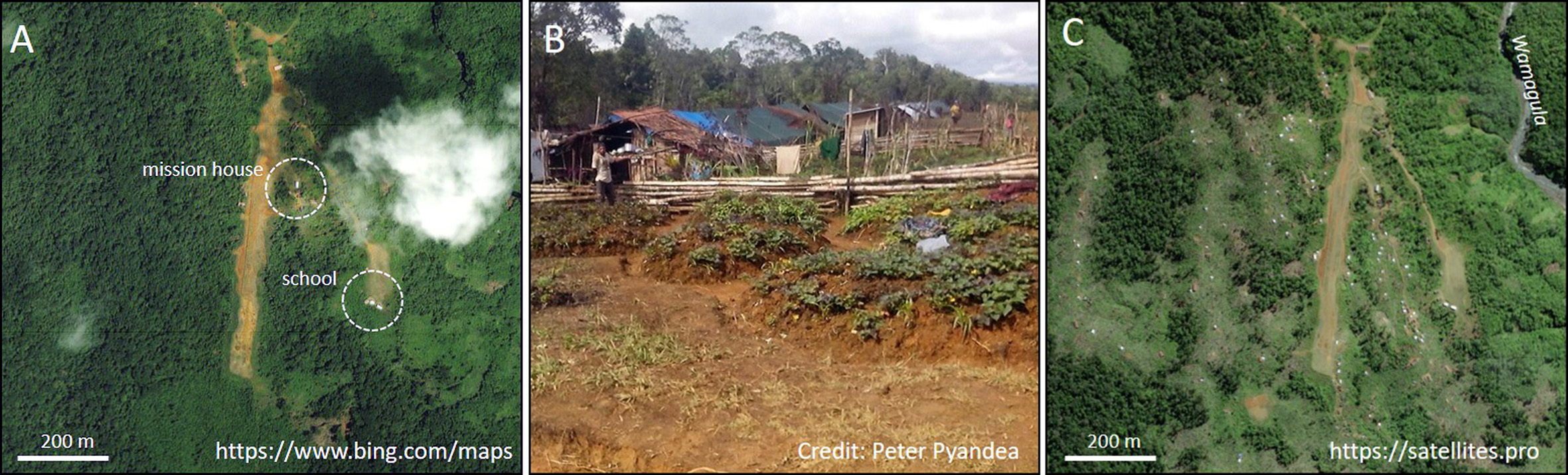
The Huya airstrip was made over a period of 10 years. The first plane landed there in early 2003 and, since then, it has been served by planes associated with Summer Institute of Linguistics and Mission Aviation Fellowship. By 2016, the population at Huya was 192 men, women and children.
The first earthquake struck on 26 February 2018. Through the next weeks men, women and children from Galoma, Aya, Fufuleya, Fau, Damalia, Namosado and Bobole (Figure 2) sought refuge at Huya. Many built temporary houses alongside the airstrip and made small garden plots near these (Figure 4B). Through the next two years the refugees built more than 100 houses on ridgetops near to, and immediately west of, the airstrip (Figure 4C).
The location of gardens, 2018
Soon after displaced people arrived at Huya they commenced fencing and felling areas of forest to establish gardens that were secure from both wild and domestic pigs. In 2018, people felled 62 ha in an area of approximately 525 ha near Huya (Figure 5). In 2016-17, they had felled only 2 and 5 ha, respectively, in the same area.
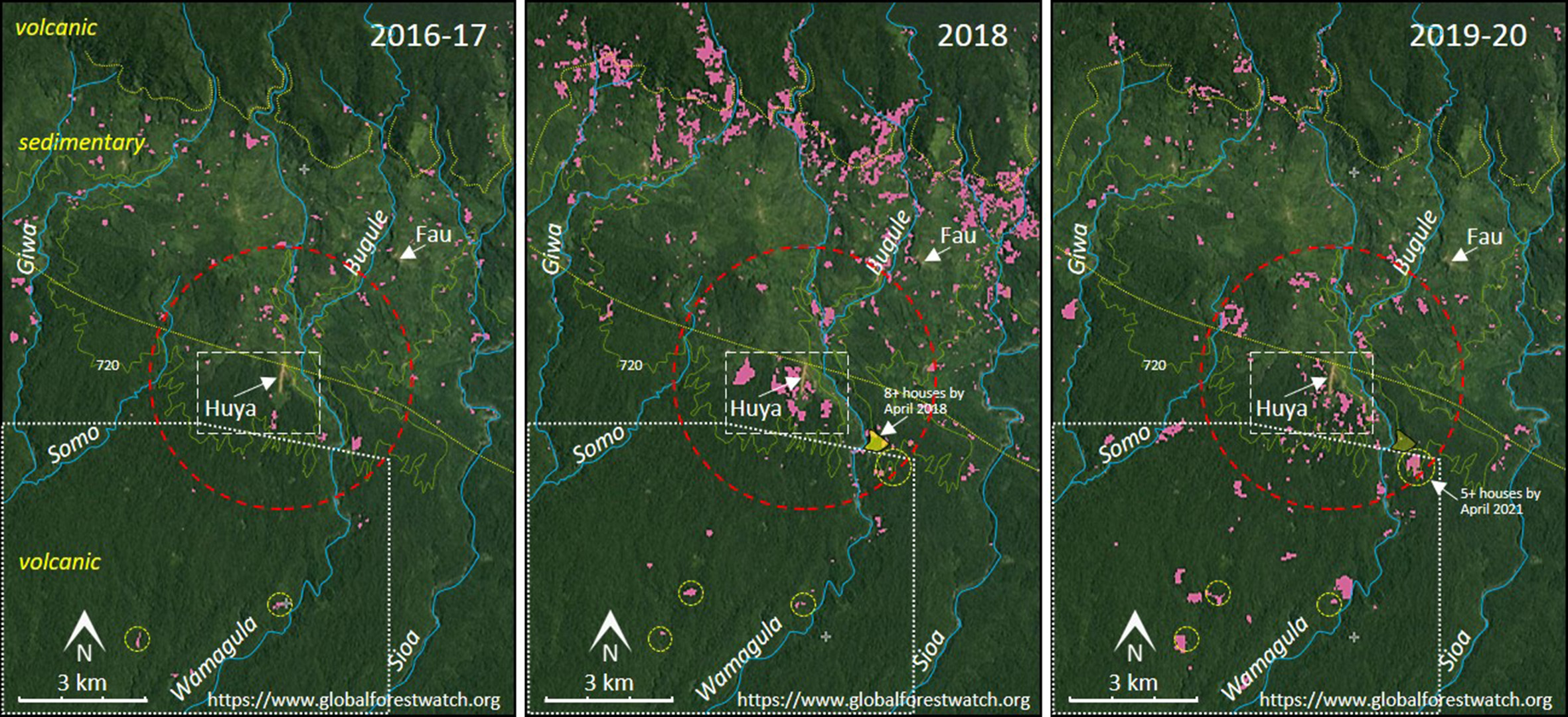
In the years 2014 to 2017, the area of forest cover loss associated with the villages of Galoma, Aya, Fufuleya, Fau, Damalia, Namosado and Huya was equivalent to 0.085 hectares per person per year for approximately 950 people. Virtually all this will have been the result of clearing forest to make gardens. However, when village sites remain in much the same place for a decade or more some gardens, made in relatively young regrowth, will not be detected as ‘forest cover loss’ in satellite imagery. With allowance for complications of this sort we think that the 62 hectares felled near Huya in 2018 will have provisioned 400 or more people through a 12-month period. This effort, therefore, reflects a capacity of Edolo people to respond relatively rapidly and effectively to disastrous circumstances.
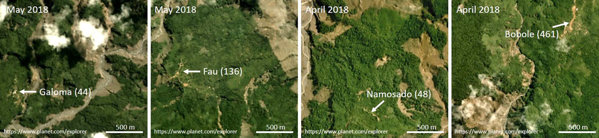
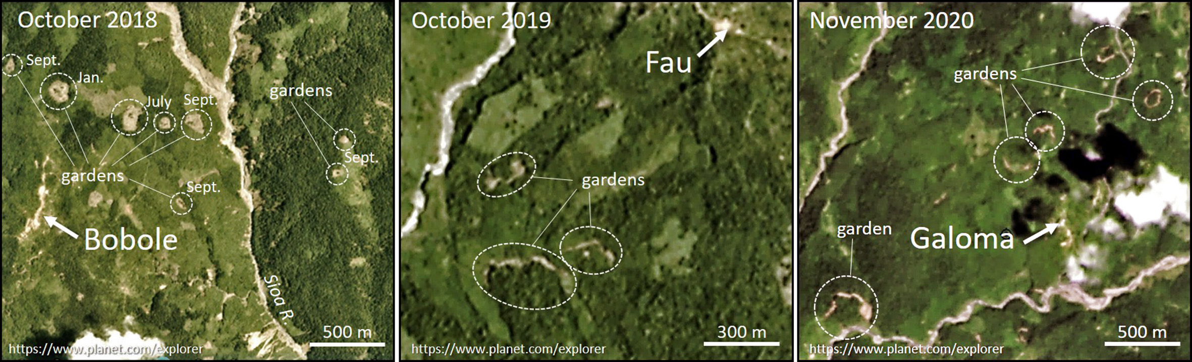
By late 2018 at least eight small gardens had been cut into advanced regrowth near Bobole (Figure 6). Some people either remained at Bobole or returned there soon after the earthquake. An early return is not unexpected. Many more people lived at Bobole than at the other communities which relocated to Huya. Further, for more than five decades, exchanges of goods and people between Edolo and the highlands has been through Bobole and it continues to be a focal way-station for highlanders who walk to and from Kiunga, more than 200 km to the west, to explore prospects for employment at the Ok Tedi mine, to engage in alluvial mining or to exchange marijuana for guns with people from the Indonesian province of Papua.
The location of gardens, 2019-20
In 2019-20 people commenced clearing forest to make gardens at greater distances from Huya. In these two years they felled only 26 and 12 ha respectively in the area of 525 ha near Huya but felled an additional 44 (2019) and 39 (2020) hectares within 3 km of the airstrip. Much of this was to the north of Huya (Figure 5).
By October 2019 some forest areas south of Fau were being fenced (Figure 6) but, other than at Bobole, it is not until late 2020 that we detect unambiguous signs of substantial areas of garden being prepared near previously abandoned villages. This was most striking near Galoma and indicates resettlement of this area.
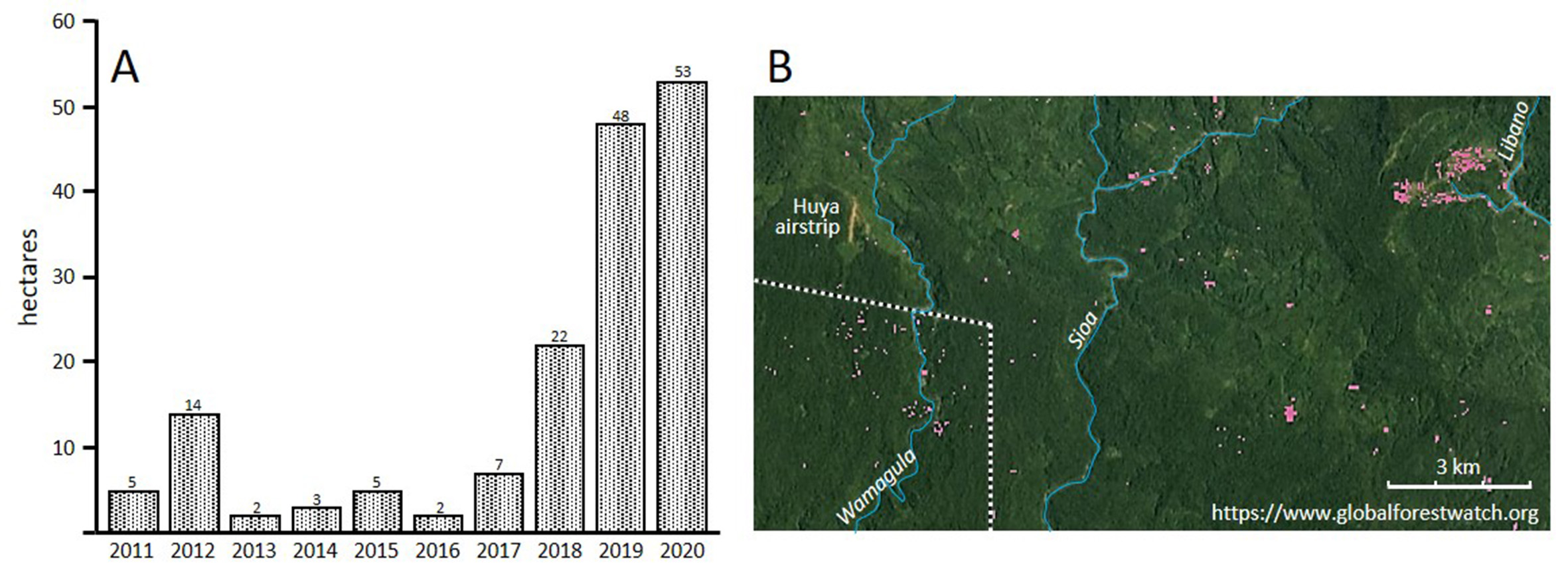
In 2019 and 2020, however, people made more extensive use of forest areas south of Huya than they had done in the previous decade. In Figure 5 the dotted white line encloses an area of 5.64 kha south of Huya. Forest cover loss from this area averaged 5.43 ha/year for the period 2011 to 2017 and, thereafter, increases from 22 ha in 2018 to 48 and 53 ha in, respectively, 2019 and 2020 (Figure 7). The 53 ha of garden in 2020 may have been enough to satisfy much of the agricultural requirements of 300 or more people across 12 months. It appears that many of the families who were displaced to Huya chose to relocate to areas that had been least damaged by landslides.
Concluding remarks
Three years after the earthquakes of 2018, the spatial patterning of Etolo subsistence gardens does not yet resemble earlier patterns. By late 2020 gardens had been made in the vicinity of most former villages but many people remained at Huya and some, probably several hundred, had redirected gardening effort to the south, well away from the escarpment near which they had lived before. For these people, long-term outcomes may be significant.
The 1974 Sisa topographic map (PNG 1:100,000 Topographic Survey, Sheet 7485, Series T683), compiled from aerial photography and colonial government patrol reports, does not show a single garden site, area of regrowth or house between 250 and 760 m ASL in the area between Giwa and Sioa rivers. Thus, some Edolo people are currently establishing a foothold on land that has been free from residential impacts for at least five decades.
To make gardens in this area people will be felling trees in primary forest rather than advanced regrowth. This will entail considerably more effort for each hectare of garden that is made. They will be planting crops in soils that overlie volcanic rock rather than sedimentary rock and this is likely to influence patterns of both crop selection and garden production (cf. Sillitoe 1998). At the lower altitudes, conditions will be less favourable than before for sweet potato and more favourable for taro. Sago palms, fish and wild pigs will be more accessible than before but because the forested slopes of Mount Sisa, north of the escarpment, will be further from living places opportunities to hunt and trap game mammals will be reduced (Dwyer 1990: 69-84). At lower altitudes, too, exposure to malaria will be increased. All these impacts will, ultimately, call for modifications to ways in which people schedule subsistence tasks and allocate tasks between men and women (Dwyer 1986).
To the extent that relocation to the south is sustained, people may well be tempted to redirect some social contacts to Kaluli-speaking communities who live south of Sioa River, and who, for many years, have been better placed for access to the outside world than those who live on the precarious slopes of Mount Sisa.
Coda: or a little of what we don’t know
Satellite imagery has allowed interpretations of some post-earthquake gardening practices by Edolo people who live in the vicinity of Huya. Those images, however, do not provide any information about impacts on three other important practices – sago processing, marita pandanus (P. conoideus) orcharding, and pig husbandry.
North of Huya, some groves of sago palms and some pandanus orchards will have been destroyed by landslides.2 Sago palms will be available at lower altitudes though here, for newcomers, issues of ownership will complicate access. Marita, however, does not grow wild and will not be immediately available in forests south of Huya. In 1979-80, 109 people at Bobole maintained about 10 ha of pandanus orchards. The oily fruit was abundant from November to May (Dwyer 1990: 61-63). It is likely that, by late 2018, people who had relocated to Huya made excursions to their orchards to harvest fruit. But for those who settle to the south it will be three or more years before newly planted marita bear fruit.
As is common elsewhere in Papua New Guinea, pigs are important to Edolo as a feast food and in many social exchanges. In the late 1960s and 1970s the ratio of domestic pigs to people at Gabulusado (since relocated to Aya) and Bobole approached parity and most of the animals were allowed to roam freely through areas of regrowth (Kelly 1988, Dwyer 1990: 55-61). When people moved to Huya immediately after the earthquake, women may well have carried small piglets with them but most animals will have been left behind. Some domestic pigs were probably killed in landslides, others may have become feral. Pigs, however, are highly valued. It is likely that as refugees became established at Huya, and anxiety levels subsided, some visited former living places to check on the well-being of surviving pigs. Certainly, in the months after the earthquake some people travelled out from Huya to harvest gardens and retrieve abandoned chickens (Jan Gossner, pers. comm.).
In future post-pandemic times, it may be possible to ground-truth, revise and enlarge upon these observations of ways in which Edolo people are responding to a devastating event in their lives. This would have positive outcomes both in identifying ongoing needs of those people and in addressing questions about the relative success, over a span of years, of practices people adopt when seeking a path to secure living after experiencing extreme perturbation.
Notes
Thanks to Jan Gossner, Sally Lloyd, Anton Lutz, Luke Mahoney, Peter Pyandea and Russ Stephenson for valuable help and information.
1. ‘Global Forest Change’ (https://glad.earthengine.app/view/global-forest-change) provides annual depictions of forest cover loss ‘defined as a stand-replacement disturbance, or a change from a forest to non-forest state’ (Hansen et al. 2013). In regions dominated by rainforest, such as those where Edolo live, most forest cover loss is the result of clearing for gardens, village sites and airstrips or landslides, storm-related tree fall and, less often, fire. ‘Global Forest Watch’ (https://www.globalforestwatch.org/) is a companion site that allows forest cover loss to be tracked and, for defined areas, quantified on a year-by-year basis or, cumulatively, over a series of years. Planet Explorer (https://www.planet.com/explorer/) provides monthly collations of satellite imagery that for the Mount Sisa area date back to 2016. These allow cross-referencing when interpreting imagery provided by Global Forest Change, Global Forest Watch, Google Earth, Bing Maps and Satellites.pro. We have drawn on all these resources in the present analyses.
2. Many sago palms are visible below the collapsed escarpment on the righthand side of the photograph that heads this article.
References
ADRA (Adventist Development Relief Agency) 2018. “ADRA responds to PNG earthquake.” https://www.adra.org.au/adra-responds-to-png-earthquake/
Dwyer, Peter D. 1986. “Living with Rainforest: The Human Dimension”, pp. 342-67 in J. Kikkawa and D. Anderson (eds), Community Ecology: Pattern and Process. Blackwell Scientific Publications, Melbourne.
Dwyer, Peter D. 1990. The Pigs That Ate the Garden: A Human Ecology from Papua New Guinea. Ann Abor: University of Michigan Press.
Dwyer, Peter D. and Monica Minnegal. 2018. “Refugees on their own Land. Edolo People, Land and Earthquakes.” EnviroSociety, 9 June 2018. www.envirosociety.org/2018/06/refugees-on-their-own-land-edolo-people-land-and-earthquakes
Hansen, M. C., P. V. Potapov, R. Moore, M. Hancher, S. A. Turubanova, A. Tyukavina, D. Thau, S. V. Stehman, S. J. Goetz, T. R. Loveland, A. Kommareddy, A. Egorov, L. Chini, C. O. Justice and J. R. G. Townshend (2013) “High-Resolution Global Maps of 21st-Century Forest Cover Change.” Science 342 (6160): 850-53.
Kelly, Raymond C. 1977. Etoro Social Structure: A Study in Structural Contradiction. Ann Arbor: University of Michigan Press.
Kelly, Raymond C. 1988. ‘Etoro Suidology: A Reassessment of the Pig’s Role in the Prehistory and Comparative Ethnology of New Guinea’, pp. 111-86 in J. F. Weiner (ed.), Mountain Papuans: Historical and Comparative Perspectives from New Guinea Fringe Highlands Societies. Ami Arbor: University of Michigan Press.
Mahoney, Luke, Richard Stanaway, Sandra McLaren, Kevin Hill and Eric Bergman (2021) “The 2018 Mw 7.5 Highlands Earthquake in Papua New Guinea: Implications for Structural Style in an Active Fold and Thrust belt.” Tectonics https://doi.org/10.1029/2020TC006667
Sillitoe, Paul 1998. “Knowing the Land. Soil and Land Resource Evaluation and Indigenous Knowledge.” Soil Use and Management 14: 188-193.
Zahirovic, Sabin, Gilles Brocard, John Connell, and Romain Beucher 2018. “Aftershocks Hit Papua New Guinea as it Recovers from a Remote Major Earthquake.” The Conversation, 9 April.
Peter Dwyer is Honorary Senior Fellow in the School of Geography, Earth & Atmospheric Sciences at the University of Melbourne. Monica Minnegal is Associate Professor of anthropology in the School of Social and Political Sciences at the University of Melbourne. Since 1986, they have conducted research among Kubo, Febi, and Bedamuni people of Western Province, Papua New Guinea, with a particular emphasis on social change and, most recently, impacts of the PNG LNG project on people’s lives. Their book Navigating the Future: An Ethnography of Change in Papua New Guinea was published in 2017 by Australian National University Press.