Haiti has been the unfortunate recipient of many an exaggerated moniker, including the poorest country in the Western Hemisphere, the Republic of NGOs, and the most deforested country in the Americas—to name just a few.
Concerning this latter label, virtually every single popular media description, development narrative, and academic account addressing deforestation in Haiti over the past five decades opens with the cliché citation of a grim and staggering statistic: only 2 percent of Haiti is forested.
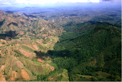
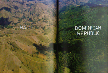
This particular narrative concerning deforestation in Haiti was thrust into the wider public consciousness when the now infamous photo depicting stark differences in arboreal coverage between Haiti and the neighboring Dominican Republic—first image—was prominently displayed in a 1987 National Geographic magazine centerfold—second image (Cobb 1987).

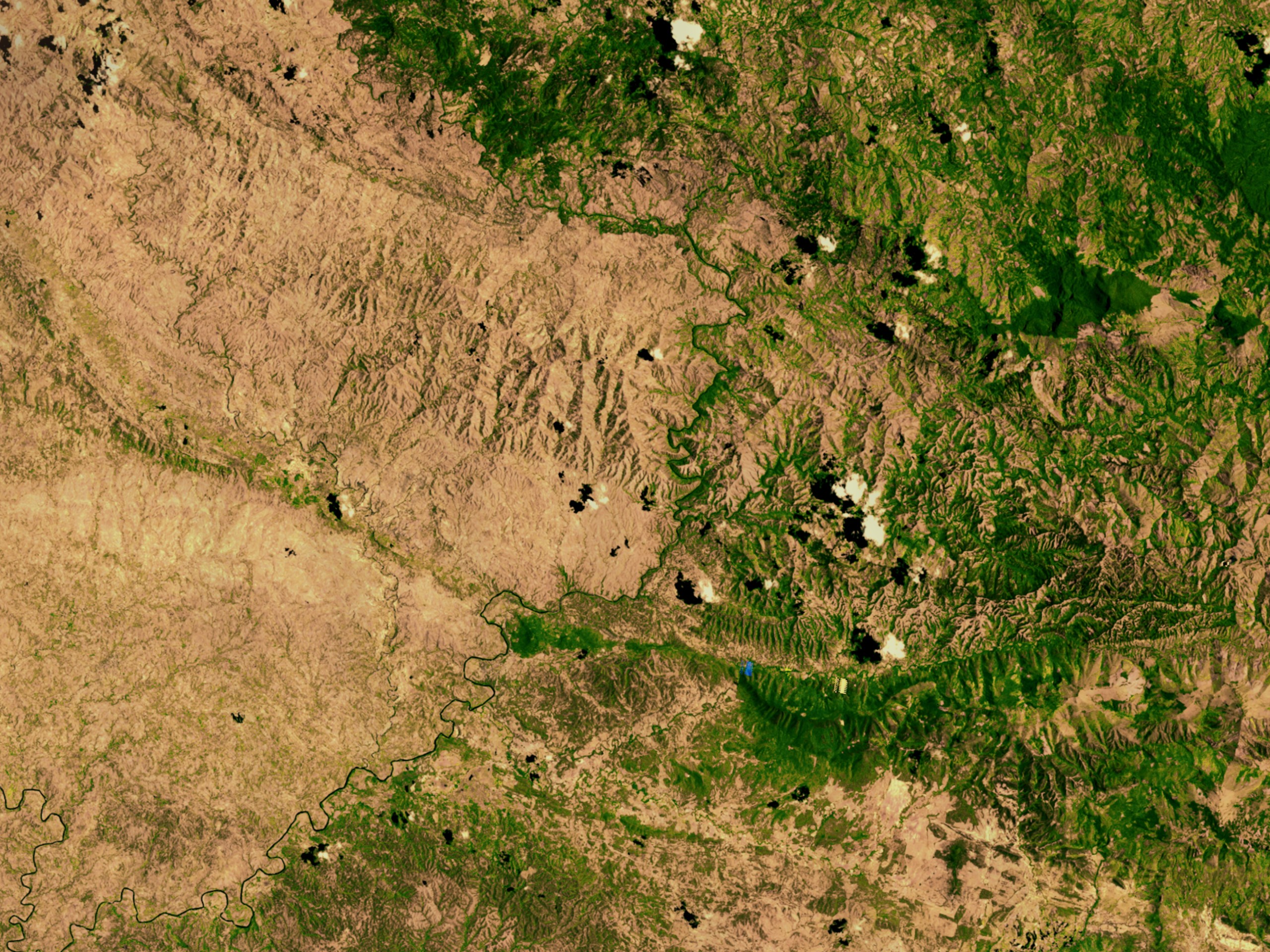
The Haiti deforestation narrative was further perpetuated in a chapter dedicated to comparing the country’s environmental condition to the neighboring Dominican Republic, in Jared Diamond’s popular book Collapse: How Societies Choose to Fail or Succeed. Another border photograph, this time a satellite image (below), surfaced in former US Vice President Al Gore’s renowned documentary on climate change, An Inconvenient Truth. Issues with all of these accounts have been raised elsewhere (Baver 2014; Bhatt 2012) but fall beyond the scope of this post.
The historical trend to saddle Haiti with dire images and descriptions has prompted many, including Haitian-American anthropologist Gina Athena Ulysses, to call for new narratives about Haiti and Haitians. In that vein, it is worth noting that contemporary Haiti is hardly devoid of tree cover.
Haitians have continued to meet their national energy needs through wood and charcoal production and consumption, despite dire warnings to the contrary. Issued as early as the 1970s, a report commissioned by the United States Agency for International Development (USAID) suggested that existing wood supplies in Haiti were enough to meet increasing charcoal demands until around the year 2000 but would eventually result in an environmental “apocalypse” (Voltaire 1979: 21, 23). The prediction that wood supplies would be exhausted by 2000 was also supported by projections based on early remote sensing analyses of aerial photographs spanning from 1956 to 1978, for three different locations in Haiti (Cohen 1984).
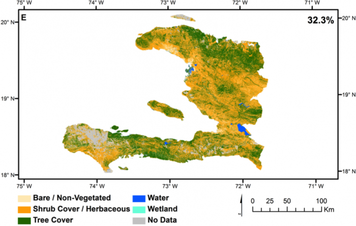
To the contrary, a recent analysis of high-resolution satellite imagery from 2010, triangulated through the ground truthing of hundreds of randomly selected locations throughout the country—suggest a contemporary tree cover of approximately a third of the surface of Haiti (Churches et al. 2014).
The unfortunate cloud cover in this image—toward the end of Haiti’s southern Tiburon peninsula—masks a large portion of one of the most heavily treed areas in the entire country and partially obscures portions of the Pic Macaya National Park; the percent tree cover for Haiti would almost certainly have been higher if the authors of this analysis had been privy to satellite imagery from a cloudless day.
Other researchers have reached similar conclusions of unconventionally high arboreal coverage in contemporary Haiti. In 2012, geographers from Virginia Tech conducted a land-use/land-change analysis of Haiti’s largest offshore island (La Gônave) using two high-resolution Landsat satellite images twenty years apart, from 1990 and 2010, accompanied by visits to hundreds of locations on the island to ground truth the image classification (White et al. 2013). These researchers found that the entire land surface of La Gônave in 2010 (excluding water and masking the less than 2 percent cloud cover) was 46 percent covered with forests and dense vegetation, and 40.4 percent covered with woody shrubs (White et al. 2013: 499).

And finally, in a broader study of land changes within the Greater Antilles between 2001 and 2010, researchers found that 26 different Haitian municipalities underwent significant changes to woody vegetation—8 decreased and 18 increased—and 48 municipalities experienced significant changes in mixed-woody/plantations—9 decreased and 39 increased (Álvarez-Berríos et al. 2013: 88–91). In overall land percentages for the entire country, woody vegetation experienced a 1 percent increase while mixed-woody/plantations increased by 4 percent, or 368 km2 (89).
Let me be unequivocally clear: Haiti is severely deforested. But anyone who has traveled extensively in Haiti can corroborate what these recent remote sensing analyses of satellite imagery have confirmed: the oft-cited figure of only 2 percent forest cover in Haiti is a gross exaggeration. Still don’t believe me? Peruse a few of many treed locations found throughout Haiti, using either Google Maps (1, 2, 3, 4, 5, 6, 7, 8, and 9) or Bing Maps (1, 2, 3, 4, 5, 6, and 7). To the astute observer, it quickly becomes apparent that easily more than 2 percent of Haiti is covered with trees and that Haiti is not only the lunar landscape that previous photographs or narratives would lead us to believe.
These new findings, grounded in overwhelmingly convincing data (it’s hard to argue with satellite imagery), raise a series of important questions. 1) Were we wrong about tree cover in Haiti all along? 2) Have we been intentionally misled by insidious development agendas pushing a reforestation agenda? 3) Has there been an arboreal expansion in Haiti in recent decades? My belief is it that the answer to the former and latter questions is a resounding “yes,” which provides the context for understanding my response to the second question—a resounding “no.”
Consultation of satellite imagery makes it apparent that many of the contemporary treed areas in Haiti are highly fragmented; consist of new, young trees; contain widely spaced trees; or are composed of a combination of all of these features, which work collectively to challenge our notion of what constitutes a “forest” in the first place. Indeed, the definition of a forest varies by individual, discipline, and institution, casting ambiguity on classifications that may add or detract to the narrative of deforestation in Haiti.
As cultural geographers Owain Jones and Paul Cloke note, researchers frequently conceptualize trees in categories such as “forests,” ‘woodlands,” and “individual trees,” and these categories propagate conceptual sub-categories such as “forests as paradisal landscapes,” “forests as spiritual landscapes,” “forests as mythological landscapes,” “forests as gendered landscapes,” and others (2002: 23–24). Said succinctly, how we conceptualize forests has a direct bearing on the narrative of deforestation and concurrent tree cover in Haiti.
It is worth noting that the United Nations Food and Agriculture Organization (FAO) definition of a forest is “land spanning more than 0.5 ha with trees higher than 5 m and cover of more than 10 percent, or trees able to reach these thresholds in situ” (2010: 209). In the nationwide study that found roughly a third of Haiti’s surface covered with trees, the authors adapted their “tree cover” classification (32.3 percent) to the FAO standard definition of “forest,” yielding a new 29.4 percent “forest” classification for Haiti (Churches et al. 2014: 211). Said differently, whether applying a looser notion of “tree cover” or applying the FAO standard definition of “forest,” approximately a third of the surface of Haiti remains covered with trees in the final analysis (Churches et al. 2014).
To return to and rephrase the first of three questions posed earlier, how were earlier researchers led to report such low areas of forest cover in Haiti? Until the recent availability of high-resolution, remotely sensed satellite imagery, estimations of arboreal coverage in Haiti relied exclusively on field site visits or qualitative assessments from aerial flyovers—typically from flights entering the country with origins in South Florida. In the case of the latter, frequent visitors to Haiti can testify that the common flight path into the country traces a trajectory along one of the most denuded areas. Relying only on qualitative assessments observed from the window of a commercial flight into Haiti, one might naturally assume that only 2 percent of Haiti remains forested. In the case of the latter, on-the-ground researchers may have been limited in travel to areas of Haiti that were accessible by vehicle. But vehicle-accessible areas in Haiti are exactly the areas most likely to be denuded because they are equally accessible to the trucks that compose the national transportation system for Haiti’s markets, bringing rural produce (and wood and charcoal) to urban areas. Perhaps researchers surveying Haiti by vehicle were in fact surveying the most easily accessible, and by extension, the most deforested areas of the country.
Returning to and expanding on the third question posed above, is Haiti experiencing an arboreal expansion, and if so, how and why? Deforestation and resulting soil loss is a major concern for the agrarian landscape of Haiti. My recent research suggests the rise of managed charcoal woodlots in Haiti correlates with an historical decline in the agricultural productivity of formally fertile land, along with increased migration to urban areas—ultimately increasing the demand and incentive for rurally produced charcoal (Tarter 2015b). Thus, it appears that in some areas of the country, to mitigate declining agricultural possibilities, Haitians have developed systems of wood production that also meet increasing urban demands for charcoal (ibid.).
Such an arboreal expansion would not be without precedent. Mark Brenner and Michael W. Binford examined fluctuations in arboreal pollen, weed types, and erosion in sediment cores from Lake Miragoâne in Haiti, providing evidence of a “temporary reestablishment of local forests and reduction of soil loss” (1988: 94) that correlates with land-use changes at the beginning of the nineteenth century. After Haitian independence in 1804, large colonial plantations were destroyed and abandoned as Haitians fanned out and established smaller agricultural settlements, frequently at higher elevations (ibid.). The authors suggest the correlated changes in pollen levels reflect an arboreal expansion during this historical period (ibid.).
These two explanations are not necessarily mutually exclusive; both may add some explanatory power to the phenomenon concerning the current tree coverage in Haiti presented by the recent remote-sensing analyses treated above. Furthermore, these explanations suggest that while misinformed narratives concerning tree or forest coverage in Haiti should be corrected, they are not necessarily the result of intentional misleading. Scientific inquiry is an iterative process, marked by revisions. As scientists, we should welcome the availability of new data and let those data inform or update our narratives.
Finally, the elephant in the room concerning narratives is the human component of this human–nature equation. My research I have endeavored to demonstrate that Haitians have developed creative adaptations to the management of trees—responding not only to changes to their environment but also to outside forces and historical market fluctuations (Tarter 2015a, 2015b).
Andrew Tarter is a social scientist that studies human–nature interactions in Haiti. Dr. Tarter is currently employed in Haiti, through the Institute of Food and Agricultural Sciences, at the University of Florida, where he received his PhD in sociocultural anthropology in 2015.
References
Álvarez-Berríos, Nora L., Daniel J. Redo, T. Mitchell Aide, Matthew L. Clark, and Ricardo Grau. 2013. “Land Change in the Greater Antilles between 2001 and 2010.” Land 2: 81–107.
Baver, Sherrie. 2014. “Hispaniola’s Environmental Story: Challenging an Iconic Image.” 2014. Callaloo 37, no. 3: 648–661.
Bhatt, Keane. 2012. “On Haiti, Jared Diamond Hasn’t Done His Homework.” The North American Congress on Latin America.
Brenner, Mark, and Michael W. Binford. 1988. “A Sedimentary Record of Human Disturbance from Lake Miragoane, Haiti.” Journal of Paleolimnology 1: 85–97.
Churches, Christopher E., Peter J. Wampler, Wanxiao Sun, and Andrew J. Smith. 2014. “Evaluation of Forest Cover Estimates for Haiti Using Supervised Classification of Landsat Data.” International Journal of Applied Earth Observation and Geoinformation 30: 203–276.
Cobb, Charles E. 1987. “Haiti: Against All Odds.” National Geographic 172, no. 5: 645–670.
Cohen, Waren B. 1984 “Environmental Degradation in Haiti: An Analysis of Aerial Photography.” Report prepared for USAID, PAP, Haiti.
FAO. 2010. “Global Forest Resources Assessment 2010: Main Report.” FAO Forestry Paper 163. Food and Agriculture Organization of the United Nations, Rome.
Jones, Owain, and Paul Cloke. 2002. Tree Cultures: The Place of Trees and Trees in Their Place. Oxford: Berg.
Tarter, Andrew. 2015a. “Trees in Vodou: An Arbori-cultural Exploration.” Journal for the Study of Religion, Nature, and Culture 9, no. 1: 87–112.
Tarter, Andrew. 2015b. “Adaptive Arboreal Practices: Haitian Farmer Responses to Ongoing Deforestation.” PhD dissertation, University of Florida.
Voltaire, Karl. 1979. “Charcoal in Haiti.” Report to USAID/Haiti. Port-au-Prince.
White, Justin, Yang Shao, Lisa M. Kennedy, and James B. Campbell. 2013. “Landscape Dynamics on the Island of La Gonave, Haiti, 1990–2010.” Land 2: 493–507.
Cite as: Tarter, Andrew. 2016. “Haiti Is Covered with Trees.” EnviroSociety, 19 May. www.envirosociety.org/2016/05/haiti-is-covered-with-trees.